On March 30, 2021, archivists Amy Stecher and Alexandra Hilton conducted a virtual “behind the scenes” look at the Manhattan Building Plans project for DORIS’s “Lunch and Learn” program. In this week’s blog Amy Stecher has adapted her presentation which focused on the challenges and complexities in preserving and digitizing the architectural plans. Next week, Alexandra Hilton will discuss some of the architectural gems that have been identified in the collection.

Fire of 1776. Library of Congress Collection.
The collection consists of architectural plans for most buildings on the 958 blocks of Manhattan below 34th Street. They date from establishment of the Department of Buildings (DOB) in 1866 through 1978. The plans had been submitted to the DOB by builders, architects, plumbers, electricians, etc., as part of the process to receive a permit to build or alter any structure.
Regulations concerning buildings pre-date the DOB. In 1625, the Dutch West India Company imposed rules for the locations and types of houses that could be built in the colony. Among the edicts were prohibitions on roofs made of reeds, and wooden or plaster chimneys. Throughout the next 200 years, city leaders enacted an array of building regulations, mostly related to sanitation and public safety, particularly from the hazard of fire. There was good reason for this. Fires devastated the city in 1776, 1835, and 1845. The 1845 fire destroyed 345 buildings in the financial district and killed 40 people. In 1816, the city banned new construction of wood-frame structures below Canal Street and in 1849 the ban was extended to 32nd Street. By 1882, no wood-frame buildings were allowed below 155th Street.
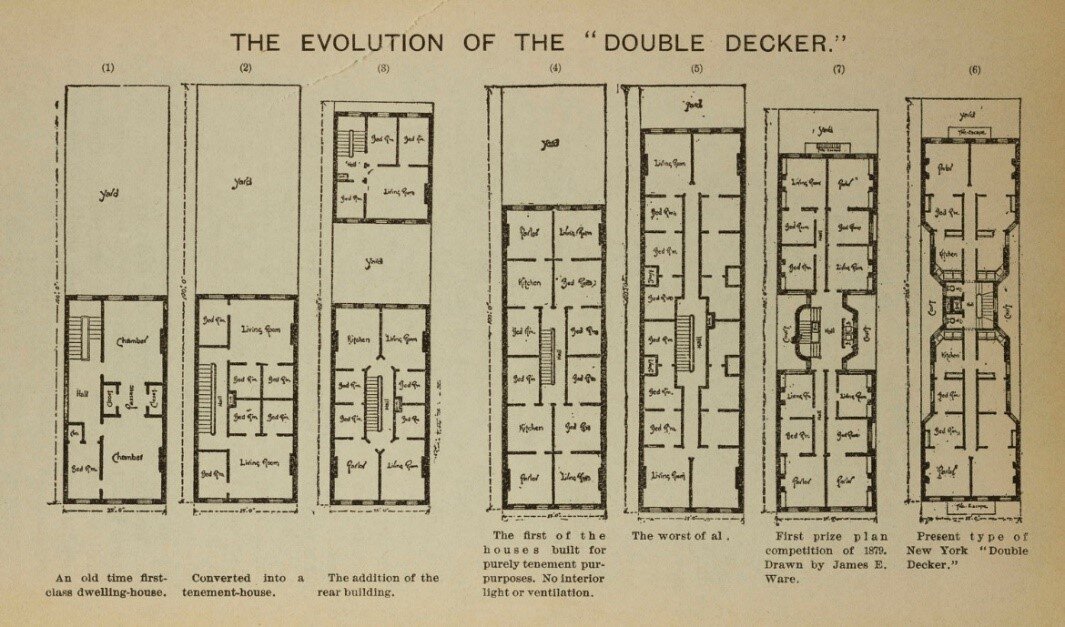
Evolution of a tenement, from single-to-multiple-family structures, an illustration from the Tenement House Commission Report of 1895. NYC Municipal Library.
In addition to fire, the exponential growth of the city necessitated additional building regulations. The city’s population increased from 60,000 people in 1800, to 800,000 in 1860. To accommodate this expansion, single-family homes were sub-divided, additional floors were added, and extensions were built into their already small yards, leaving little open space for light or ventilation. By 1865, more than 15,000 tenement-style houses had already been built.
During the 18th and 19th century the city experienced cholera, yellow fever, and typhoid epidemics. Overcrowding and close quarters with little ventilation and unsanitary conditions contributed to the spread of disease.

Caption: The introduction of new technologies such as the elevator and steel-frame construction allowed ever-larger and taller buildings to rise in Lower Manhattan. The collection includes an elaborate fire-escape for the building on Washington Place where the Triangle Shirtwaist Factory fire occurred. DOB Collection. NYC Municipal Archives.
In 1860 the New York State Legislature passed “An Act to provide against unsafe buildings in the City of New York…,” calling for the appointment of a Superintendent of Buildings and a staff of inspectors. Over the next 40 years, the city and state enacted new regulations, including establishment of the Bureau of Fire Escapes and Iron Work in 1874, and the Bureaus of Plumbing, Light, and Heat in 1892.
Other laws passed in 1867 and 1879 mandated fire escapes but failed to adequately address issues of light and ventilation. This resulted in the Tenement Act of 1901, which imposed many more regulations, such as requiring new buildings to have outward-facing windows, indoor bathrooms, proper ventilation, and increased fire safeguards. Population growth also meant that the City’s economy grew and became more complex, creating the need for larger and more versatile spaces.
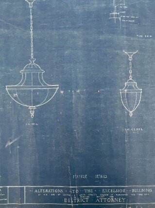
Advances in the water supply system, sanitary engineering, access to gas and electricity for illumination and cooking, and central heating systems added to the complexity of building construction and to the variety of types of plans that needed to be filed. New lighting fixtures in the District Attorney’s office on Centre Street. DOB Collection. NYC Municipal Archives.

Of the thousands of plumbing drawings, one of our favorites is a very artistic sink and toilet drawing for the Manhattan House of Detention. DOB Collection. NYC Municipal Archives.

Permit and application correspondence in block and lot folders, DOB Collection. NYC Municipal Archives.
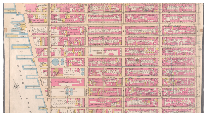
Permit applications and filed plans are arranged according to the Block and Lot number, a system that provides every city parcel of land with a unique identifying number. Insurance atlases are a helpful tool in identifying historical block and lot numbers. 1897 Bromley Atlas. New York Public Library online resource.
Increasingly, trained architects and engineers, rather than tradespeople and builders, were needed to navigate the complexities of the system and to submit plans and application forms. The DOB retained the bulk of these materials until the early 1970s when it initiated a pilot project to save space by microfilming the building plans that had accumulated over the previous century. They employed an outside vendor for the microfilming, intending to dispose of the original materials after filming. The idea of disposing of the original material raised alarms among the city’s community of historians, architects, and preservationists, including the Landmarks Preservation Commission. They monitored the quality of the microfilm and it was determined that the film did not meet accepted standards. The project was discontinued after filming the surviving plans for all buildings on the 958 blocks of Lower Manhattan below 34th Street. At that point they transferred the plans to Municipal Archives.

Roll plans from the DOB in storage. NYC Municipal Archives.
In 1979, an initial group of 1,000 rolls of blueprints and plans were transferred to the Municipal Archives, and more kept coming. By 1984, the archives conducted an inventory of the accumulated rolled plans and concluded that they had acquired a total of 5,738 rolls of plans. Until 2018, these plans were in storage in the same state they arrived in, occasionally being pulled by archives staff for use by researchers if they knew they existed.
In 2018, the Municipal Archives received support from the New York State Library Conservation/Preservation Discretionary Grant Program to process and re-house a subset of the Manhattan Building plans that pertained to the neighborhoods of Tribeca and Soho. This allowed staff to be hired to begin to process the plans. After the approximately 140 blocks encompassing those two neighborhoods were completed in the fall of 2019, the archivists started working on the lowest blocks in Manhattan.

Poor storage conditions and improper handling during the microfilming process resulted in damage to the plans. DOB Collection. NYC Municipal Archives.
Less than ideal storage conditions have led to some daunting issues in processing the collection. The microfilm vendor haphazardly and messily rewrapped the plans in acidic wrapping paper tightly tied with damaging twine and labelled the “bundle” with minimal, and often insufficient, information.
It’s a big task for our rolled plans processing team to process and rehouse these plans to reestablish intellectual control over the material and to create more optimal retrieval and storage conditions. Here is a look at some of the tasks we perform on each roll.

Plans separated by mylar and re-rolled. DOB Collection. NYC Municipal Archives.

The re-rolled plans are stored in archival containers. DOB Collection. NYC Municipal Archives.
First, the dusty bundles are un-rolled and the plans are identified, sorted, flattened, repaired if damaged, counted and cataloged, and carefully and neatly re-rolled onto acid-free tubes, wrapped with protective Mylar, and stored in acid-free boxes. The method for organizing the plans is according to the building’s block and lot number; all the plans for all the buildings or structures built on a particular city lot, and all the changes and alterations made to an already existing building on that lot, are stored together. When sorting the plans, we verify the block and lot information and record it in a spreadsheet, as well as addresses, quantity of plans, dates, and notes on architects, important features, and major condition concerns that are passed on to our conservation department.
A block can contain up to 70 or 80 lots, sometimes all rolled together. Over time, when buildings are expanded or torn down, and new larger buildings are built, or buildings are combined, the lot number can change. The lot numbers written on these plans (often written very boldly in horrifying black magic marker!!!!) are essentially only accurate for the location identification as it was in the 1970s. This mean that we do not know the contents of a bundle until it is unrolled.
When we identify the plans, we record the block and lot number from when the plan was filed as well as the current identifying information listed in the DOB BIS (Building Information System). Our concern is that researchers might request materials based on numbers from the DOB BIS, or from insurance atlases, or old block and lot maps, which may not match up with 1970s labeling. Our goal is to provide multiple entry points.

After unrolling, plans are under boards and light weights. DOB Collection. NYC Municipal Archives.
The drawings span more than 100 years and many print types created by many different processes are represented in the collection. During processing they are sorted according to print type and separated by sheets of Mylar to avoid chemical migration between the different types of plans.

Plan types. Blueprint. DOB Collection. NYC Municipal Archives.

Plan types: Aniline print. DOB Collection. NYC Municipal Archives.

Plan types. Drawing on drafting linen. DOB Collection. NYC Municipal Archives.

After processing, the containers and re-shelved. DOB Collection. NYC Municipal Archives.
We have processed almost 30,000 drawings but there’s a lot more work to be done! Clearly, it is a really big, multi-year project, but it’s very worth it. Now, when we receive inquiries about plans from researchers, we can tell immediately whether we do or do not hold plans for a particular address or block and lot number, and can supply quantity and date information simply by checking the spreadsheet. Retrieval of the actual plans once they are processed takes minutes instead of hours and almost everything that has been processed is in a state that is now ready for scanning because the flattening and repair has already been performed. As of now we are scanning on demand for researchers as well as digitizing particularly interesting or beautiful plans so they can be part of our online gallery.
It’s also worth doing the work because the collection has so much to offer that is now becoming more accessible to the public.
Look for next week’s blog where we highlight some of the amazing plans that have been identified in the collection.

New York Life Insurance Building, , elevation, McKim Mead & White, 1903. Manhattan Building Plan collection. NYC Municipal Archives.