Anniversary of Wall Street

The 13th of March marks another important anniversary in the history of New Amsterdam. For on March 13, 1653, less than two months after New Amsterdam formed its first municipal government, it faced an existential threat. The 1st Anglo-Dutch war had broken out in late 1652, and word had reached Governor General Petrus Stuyvesant and the council of Burgomasters and Schepens that English troops were amassing in New England for a possible overland invasion from the north. From the records of New Amsterdam:

“Upon reading the letters from the Lords Directors [of the Dutch West India Company in Amsterdam] and the last received current news from New England concerning the preparations there for either defense or attack, which is unknown to us, it is generally resolved:

First. The burghers of this City shall stand guard in full squads overnight…

Second. It is considered highly necessary, that Fort Amsterdam be repaired and strengthened.

Third. Considering said Fort Amsterdam cannot hold all the inhabitants nor defend all the houses and dwellings in the City, it is deemed necessary to surround the greater part of the City with a high stockade and a small breastwork….”[1]

From the 13th to the 19th of March 1653, they discussed the plans for defense and how to bid out the work. And on the 17th, someone, possibly even Stuyvesant himself, drew a little sketch in the margins of the court record of a cross-section of the defenses, consisting of a ditch, embankment and palisade wall. The wall built by the spring of 1653 to defend against the English would eventually give its name to Wall Street (although the Dutch called it Het Cingel, the Belt). All of this I have covered thoroughly in past blogs, but a few new questions have arisen concerning the history of the wall.

Court minutes from March 17th, 1653. The sketch of the wall is in the margin in the middle. Records of New Amsterdam, NYC Municipal Archives.

Diagram of the proposed wall from the Court Minutes of New Amsterdam, March 17, 1653. Records of New Amsterdam, NYC Municipal Archives.

The exterior has an embankment and a ditch, and the line projecting from the top of the wall may be a fraise, small sharp sticks to impede scaling the wall. The Dutch reads: “9 feet above ground, 3 feet in ground.” One dot = one foot. In the end a palisade proved too costly, and they used slats across posts set 15 feet apart.

A recent Bowery Boys podcast about the wall kindly directed listeners to my earlier blogs. However, one part of the story intrigued/stumped me. They reference an earlier wall built in 1644 near the end of Governor Kieft’s war with the native tribes. Was it possible that the wall really was built to defend against attacks by the natives and not the English? This blog explores that possibility and raises new avenues for exploration. The language quoted in these records obviously reflects the viewpoints of the Dutch colonial government. The Municipal Archives plans to add new content to New Amsterdam Stories by 2024 describing colonization from the perspectives of the original Munsee Lenape inhabitants and enslaved peoples to coincide with the 400th anniversary of Dutch settlement on Manhattan. These long over-due stories were originally planned when the website was launched, but the relocation of our offsite collections and COVID disrupted these plans.

The source for the 1644 wall claim is a Curbed New York article that references an article in Harper’s magazine “The Story of a Street,” from 1908, by Frederick Trevor Hill. In it, Hill wrote that on March 31, 1644, Kieft ordered a barrier to keep in stray cattle and defend against Native Americans. Hill was a lawyer and historian, and his enjoyable, but rather fanciful, article does get some things right, like this footnote:

“About this time (1655-6) the residents of Pearl Street, inconvenienced by the high tides, caused a sea wall to be erected, and the space between this barrier and their houses to be filled in, making a roadway known as De Waal, or Lang de Waal. Incautious investigators have confused this with Wall Street, and their error has resulted in some astonishing ‘history.’”

Very true. Since he was correct about this, his 1644 claim bears investigating. For the original source we need to go to records in the New York State Archives:

“31st of March [1644]

Whereas, the Indians, our enemies, daily commit much damage, both to men and cattle, and it is to be apprehended that all of the remaining cattle when it is driven out will be destroyed by them, and many Christians who daily might go out to look up the cattle will lose their lives; therefore, the director and council have resolved to construct a fence, palisade, or enclosure, beginning from the great bouwery to Emmanuel’s plantation. Everyone who owns cattle and shall desire to have them pastured within this enclosure is notified to repair there with tools next Monday morning, being the 4th of April, at 7 o’clock, in order to assist in constructing the said fence and in default thereof he shall be deprived of pasturing his cattle within the said enclosure.”[2]

Already the claim starts to fall apart, as what is described is a cattle pen not a defensive wall. The main concern seems to be that cattle would wander up-island when put out to pasture, which was dangerous for the cattle and for colonists who were in the woods looking for them. Earlier records scold colonists for letting their cattle trample the maize fields, which caused conflict with the Lenape and hurt the supply of grain for the colonists. Incidentally, the next two passages in the state records are notices of the peace treaties signaling the end of the war.

So not a wall, but where was this cattle fence? Hill thought it ran from “William Street… to what is now Broadway, and possibly from shore to shore, marked the farthest limits of New Amsterdam, as it then existed, and practically determined the location of Wall Street.”[3] Hill then went on to colorfully describe Stuyvesant in 1653 “stumping along the line of Kieft’s old cattle guard, seeking an advantageous location for the Palisade…” and placing it “some forty or fifty feet south of the old barrier and practically parallel to it….”[4]

Map of the Original Grants of village lots from the Dutch West India Company to the inhabitants of New-Amsterdam, (now New-York), lying below the present line of Wall Street, grants commencing A.D. 1642. Map created by Henry Dunreath Tyler, ca. 1897. Courtesy New York Public Library. Hill may have seen this map produced 10 years before his article, for he thought the cattle enclosure started east of the Sheep Pasture, and extended to Broadway, but there are no patentees on this map named Emmanuel.

Was this really the correct location? According to the original 1644 records, the enclosure was to run from “the great bouwery to Emmanuel’s Plantation.” Bouwerie is Dutch for farm, and the street now named Bowery was indeed the road that led to tracts of Dutch farmland. The “Great Bouwery” most likely referred to the large tract of Company farmland that ran from Bowery Street to the East River, later to become Stuyvesant’s farm, but all these large farms were north of present-day Worth Street. And where was Emmanuel’s Plantation? Historian I.N. Stokes identified Emmanuel as Emmanuel Pietersen. No map shows the exact location of his farm, but Stokes notes that Emmanuel was previously known as Manuel Minuit, perhaps because he had been enslaved by Pieter Minuit, founder of New Amsterdam.[5]

The large Dutch farms were located east of Bowery [the dashed line from point 4 to 16] in what would now be the East Village and Lower East Side. The “Great Bouwery” is number 1 on the map just above #16 (the Brewery). The key says “No1 Comp Bouwery met Een Traffelleyck Huys” [Company’s Bouwery with an excellent house]. Eventually this would become Stuyvesant’s farm. The farms given to freed Blacks in 1644 likely stretched from numbers 9 to 10 on this map. Jan Pietersen’s Plantation (#9) was just above Spring Street near Minetta Creek. It is possible Emmanuel had worked this land and was given the northern portion. Manatus Map [detail], 1639. Courtesy Library of Congress.

Key to the Manatus Map, 1639. Courtesy Library of Congress.

Less than two months before the fence ordinance, on February 25th, 1644, the Dutch West India Company resolved the petition of ten enslaved men who were demanding their freedom. They were granted conditional freedom for themselves and their wives, but not for their children who remained enslaved to the Company. The Company gave them farmland north of the town that had been abandoned by white settlers during Kieft’s war. The area became known as the Land of the Blacks, and eventually remnants of it were called Little Africa. Emmanuel was not one of the ten men, probably having gained his freedom earlier, but he would later marry Dorothy Angola, the widow of Paulo Angola, one of the ten. Together, Dorothy and Emmanuel merged their farms and successfully petitioned for the freedom of Dorothy’s adopted son Anthony in 1661.
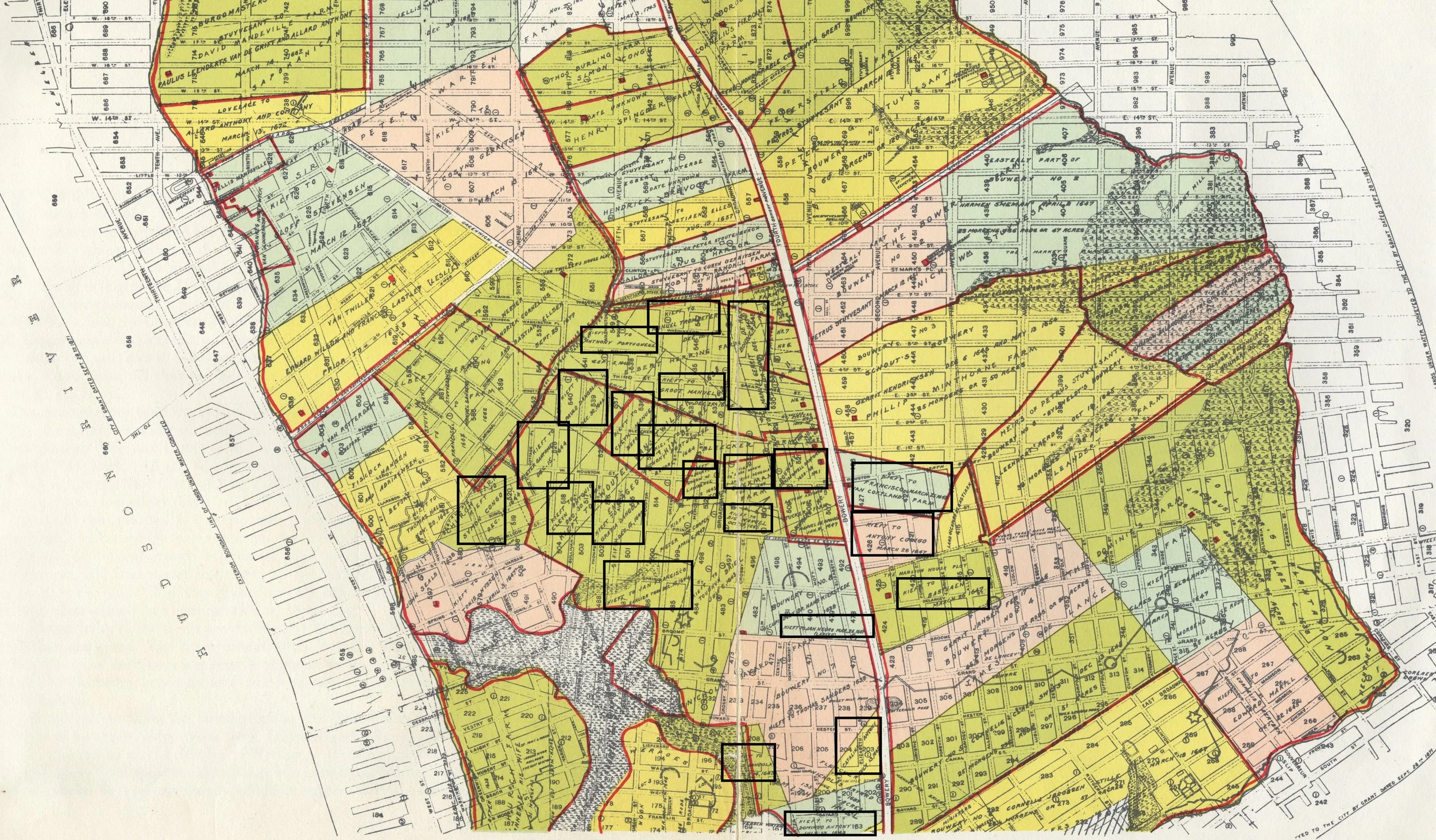
Map of the Herring Farm from 1869. Manhattan Farm Maps, NYC Municipal Archives. The corner of the property in the middle of Washington Square Park is where the Lenape path that became Old Sand Road intersected with Minnetta Creek. Stokes says these formed the border of the cattle enclosure.

The vertical line shows the path that would become known as Bowery Road, but was originally the same up island trail that was incorporated into Broadway. The path westward to the Hudson River became known as Sand Hill Road until it crossed Minetta Creek, and still exists past that point as Greenwich Avenue. Stokes thinks the 1644 cattle fence followed this path from Bowery to Minetta Creek. These paths connected Lenape villages, farms and hunting and fishing grounds. From Indian paths in the great metropolis by Reginald Pelham Bolton, published by the New York Museum of the American Indian and Heye Foundation, 1922.

All of this is fascinating history, but is this anywhere near Wall Street? No, it is not. It is in what are now the East and West Villages. Stokes suggested the cattle fence “ran west from the Bouwery Road, along ‘the old highway’ (the Sand Hill Road), as far as Minnetta Water, where the bridge crossed the road to Sapocanikan…. Then westerly along the line between the later Warren and Herring farms to Emanuel’s land (near the corner of West Third and Macdougal Sts.).”[6] This is a bit confusing, but Sand Hill Road was an old Lenape trail that “commenced at the Bowery, and ran across that part of the city now known as Waverley Place, on the north side of Washington-Square, then Potter’s Field…”[7] The eastern bit of this road still exists at Astor Place and Greenwich Avenue preserves its western terminus. “Minnetta Water” was a fresh water stream now buried under Minetta Street. It originally flowed from around Union Square southwest to the Hudson River and would have formed a natural border for the enclosure. The line described by Stokes can be seen on a map of native trails, and on the farm map above as the northern border of Herring Farm. And lastly, Sapohanikan was a Lenape fishing settlement on the other side of Minetta. Although the Dutch had violently pushed the Lenape out by 1644, the area known as Greenwich Village (Greenwijck in the original Dutch) was still called Sapocanikan until the English colonial period.

Sanitary & Topographical Map of the City and Island of New York (1865) by Egbert Ludovicus Viele. Courtesy New York Public Library. Minetta Creek ran through Washington Square and determined the border of the Herring Farm. A remnant of Sand Hill Road can be seen above Washington Square Park and at Astor Place in this map. In 1644 ten formerly enslaved men and their wives were given land grants south of this area.

Why was Hill so convinced the location of this pasture was so much further south? Perhaps he was confused by an 1897 map showing a marshy sheep pasture within the City limits in 1642, along with the original Dutch land grants. But there are no grantees named Emmanual shown on this map, nor any great farm. The name Emmanuel or Manuel is not Dutch, but it was a common name amongst many of the early enslaved Africans in New Amsterdam, suggesting that they had been seized from Portuguese or Spanish ships or were from Portuguese colonies in West Africa. Although there were other Manuel’s recorded in 1644, all of them were part of the group of freemen given properties in the Land of the Blacks.

This finally brings us to one more recent online myth about the wall, that part of the reason for its construction was to keep out the freed black colonists north of the wall. Perhaps the origin of this concept was the close timing between the February 1644 land grants and the March 1644 “fence” construction, but as we now see not only was this 1644 project not a wall, but if Stokes is right, it also ran right across the Land of the Blacks, with most of the farmland south of the fence.

New scholarship may reveal more definitive answers, but unless new information comes to light, March 13, 1653 remains the birthday of Wall Street.


After publishing this blog another reference to the fence turned up while trying to find the location of Emmanuel’s plantation. In D.T. Valentine’s 1866 Manual of the Corporation Council, writing about the lands given to freed Blacks in 1644 he writes:

“We find, as further corroboration of the idea that the negro settlement was designed as an outpost, the fact that in the same year a great inclosure was established in the center of the negro settlements for the protection of the cattle of the whites. It had been a prominent object in the economy of the newcomers to increase the number of domestic animals, and for that purpose they were allowed to run at large through the forests covering the island, insomuch that at a much later period it is recorded that the woods were filled with animals almost as wild as when in their native condition. They were yearly driven by a grand turn-out of the cattle proprietors into an inclosure for the purpose of branding the yearlings, when they were all set loose again. The Indian troubles required more careful herding of the cattle than that alluded to, and hence, by resolution passed in the Provincial Council in 1644, it was decided that a clearing be made on Manhattan Island, extending from the Great Bowery (afterward Stuyvesant’s) to Emanuel’s plantation (Manuel the negro); and all inhabitants who wished to pasture their cattle within the clearing, to save them from the Indians, were required to appear by a certain day to assist in building a fence around the same.”

Valentine was not great in citing his research, but further evidence of the location of the 1644 cattle fence.


[1] Fernow, Berthold, The Records of New Amsterdam from 1653 to 1674, vol. 1, pp. 65-66

[2] Van Laer, Arnold J.F., New York Historical Manuscripts, Dutch, v. 4, p.216

[3] Hill, Frederick Trevor, “The Story of a Street,” Harper’s Monthly Magazine, 1908, p. 688

[4] Hill, p. 690

[5] Stokes, I.N., Iconography of Manhattan Island, v.6, p.76

[6] Stokes, v. 6, p. 76

[7] Ibid, v. 6, p. 50

Mayor David N. Dinkins, A Photo Medley

New Yorkers went to the polls on election day, November 7, 1989, and elected David N. Dinkins as the City’s first black Mayor. Inaugurated on January 1, 1990, Dinkins served one term, through December 31, 1993.

Photographer: Joan Vitale Strong, Mayor David Dinkins Photograph Collection, NYC Municipal Archives.

Collections of mayoral photographs in the Municipal Archives date to the administration of Fiorello LaGuardia. This week’s blog is a picture essay, highlighting images from the Dinkins mayoralty.

Mayor Dinkins’ staff included photographers who documented his daily activities and the surrounding environment. The pictures begin with the January 1, 1990 inauguration ceremony and continue through his next-to-last-day in office, on December 30, 1993, when he held an Open House at City Hall.

As required by the City Charter, the Municipal Archives accessioned the collection of prints and negatives, along with the paper records in 1994. They constitute approximately 35,000 images, and total 70 cubic feet.

Although the activities of earlier mayors were documented by city photographers, the practice of employing full-time dedicated photographers to document mayoral activities began with the administration of Mayor Koch in 1977. Koch’s photograph collection is also maintained in the Municipal Archives.

Mayor Dinkins’ photographers, Joan Vitale Strong, Diane Bondereff, and Ed Reed continued the same system as devised by Mayor Koch’s chief photographer, Holly Wemple. The process began with a request from a mayoral staffer, usually a person in the press office, submitting a form to the “Mayor’s Photo Unit.” The form specified the name, date, time, and place of the event as well as the intended use of the photographs, i.e. publication, or “personal.”

The photographers used 35mm SLR cameras. Although the bulk of the pictures were shot on black and white film, some of the more important events, such as the reception and ticker-tape parade for South African leader Nelson Mandela, were also documented in color.

The photographs taken at each event are filed in individual folders labeled with the date and subject. The folders contain negatives of the pictures, cut into strips, stored in archival sleeves; contact sheets; and often, prints of selected images in a variety of sizes. The photographers generally chose one or two of the best shots—usually the most flattering of the Mayor—to be printed and distributed to newspapers and/or other persons who appear in the pictures.

The folders also contain other useful information and related paperwork such as press releases, memos with further details about the event, background information, and the names of media outlets where prints were sent for publication.

The bulk of the pictures in the collection document “meet-and-greet" events and press conferences at City Hall and Gracie Mansion. The photographers also accompanied the Mayor on visits and appearances he made throughout the city.

Mayor Dinkins was visiting Japan when the first bombing took place at the World Trade Center on February 26, 1993. He toured the site on March 1, and three weeks later he invited students from P.S. 91 to visit with him in City Hall. The class, one of several public school groups visiting the World Trade Center during the February 26th bomb blast, was stuck in an elevator for nearly six hours.

Mayor David Dinkins and First Deputy Mayor Norman Steisel tour the site of the World Trade Center explosion, March 1, 1993. Photographer: Diane Bondareff. Mayor David Dinkins Photograph Collection, NYC Municipal Archives.  

Mayor David Dinkins speaks with a class from P.S. 91, City Hall, March 24, 1993. Photographer: Joan Vitale Strong. Mayor David Dinkins Photograph Collection, NYC Municipal Archives. 

A tennis enthusiast, Mayor Dinkins negotiated an agreement with the United States Tennis Association that kept the U.S. Open Tennis Tournament at Flushing-Meadows. Mayor David N. Dinkins with John McEnroe (left) and Arthur Ashe (right), at the U.S. National Tennis Center, Queens, April 22, 1992. Photographer: Joan Vitale Strong. Mayor David Dinkins Photograph Collection, NYC Municipal Archives.

Mayor Dinkins’ establishment of the “Safe Streets, Safe City,” program was one of the highlights of his administration. Mayor Dinkins receives a gift from Loisaida Inc. at a visit to a youth center expanded with funding from the new program, Lower Eastside Action Program, December 6, 1990. Photographer: Joan Vitale Strong, Mayor David Dinkins Photograph Collection, NYC Municipal Archives.

Mayor David N. Dinkins celebrates the “Earth’s Birthday Party” with Carly Simon and a party of pre-schoolers who each released a butterfly that they had raised from caterpillars. April 20, 1990. Photographer: Joan Vitale Strong, Mayor David Dinkins Photograph Collection, NYC Municipal Archives.

Mayor Dinkins announces accessible bus and transit options with Anne Emerman, Commissioner of the Office for People with Disabilities, at the 125th Street subway station, June 29, 1990. Photographer: Joan Vitale Strong, Mayor David Dinkins Photograph Collection, NYC Municipal Archives.

Mayor Dinkins pays a courtesy call with Dalai Lama of Tibet, the Regent Hotel, September 11, 1990. Photographer: Joan Vitale Strong, Mayor David Dinkins Photograph Collection, NYC Municipal Archives.

Mayor Dinkins jams with Paul Simon at a press conference announcing free summer concerts, City Hall, July 28, 1991. Photographer: Joan Vitale Strong, Mayor David Dinkins Photograph Collection, NYC Municipal Archives.

Mayor Dinkins meets with graduates of the Volunteers of American Sidewalk Santa “school,” City Hall, December 24, 1990. Photographer: Joan Vitale Strong, Mayor David Dinkins Photograph Collection, NYC Municipal Archives.

Mayor Dinkins helps serve Christmas dinner to members of the Grand Central Partnership Multi-Service Center, a drop-in site for the homeless, Grand Central Terminal, December 24, 1991. Photographer: Ed Reed, Mayor David Dinkins Photograph Collection, NYC Municipal Archives.

From Marketfield to the Greenmarket, Part II: The Market Man

This is Part 2 of a series. Read Part 1

Thomas F. De Voe in his Jefferson Market butcher stall. Frontispiece to The Market Assistant, 1867. Robert Hinshelwood, from a sketch by T.F. De Voe. Courtesy New York Public Library.

From the earliest days of the Dutch colonial settlement, butchers were at the top of the market hierarchy and their profession was tightly regulated. By the 1800s, their status was signaled by their attire, as they had taken to wearing tall top hats and tails as part of their work outfit—a look that might be familiar from the character of “Bill the Butcher” in the film Gangs of New York. In the 1850s, a well-respected Jefferson Market butcher by the name of Thomas F. De Voe, by his telling, was searching for something to do in his leisure hours. An officer of the 8th Regiment with an interest in military history, he visited the New-York Historical Society and was “bitten by a rabid antiquary.”[1] Discovering the Records and Files of the Common Council [now held by the Municipal Archives] he realized that they contained a wealth of historical information about his profession. (In actuality, he may have been conducting research to better represent himself and other butchers in regulatory matters.)

Petition of Thomas F. De Voe, Butcher, 1854. Board of Alderman, Approved Papers. NYC Municipal Archives. De Voe petitioned the Committee on Markets in 1849 and again in 1854 detailing what he saw as actions by the Superintendent of Markets that undercut the value of his stall. He later had a printed version of his 1854 petition produced but the Market Committee files include his handwritten copy and pages of his testimony before the Boards of Aldermen and Councilmen of the City.

Encouraged by the Historical Society librarian to write a paper on the subject of markets, De Voe soon entered the circle of mid-19th century historians who were preserving the history of the City, including D.T. Valentine, Clerk of the City, and E.B. O’Callaghan, who was busy translating the Dutch records of New Amsterdam. After a well-received 1858 presentation of his paper at Cooper Union, De Voe published in 1862 The Market Book: Containing a historical account of the public markets of the cities of New York, Boston, Philadelphia and Brooklyn with a brief description of every article of human food sold therein, the introduction of cattle in America, and notices of many remarkable specimens. For its time, it is a masterpiece of research. Drawing on his own experiences and using the writings of O’Callaghan and Adrian Van der Donck for Dutch history, and the records of the Common Council for colonial history, he detailed every bit of minutia on markets from the 1600s to the 1800s. The scholarly respect was mutual, as D.T. Valentine commissioned him to write a history of the “Old Fly Market Butchers” for his manual of 1868. Only volume 1 of the Market Book, on the public markets of New York, was published, but in 1866 De Voe published a paper Abattoirs and in 1867 he published The Market Assistant, containing a brief description of every article of human food sold in the public markets of the cities of New York, Boston, Philadelphia, and Brooklyn including the various domestic and wild animals, poultry, game, fish, vegetables, fruits, &c., &c. with many curious incidents and anecdotes. It included several engravings from sketches by De Voe, including a frontispiece of the man himself in his shop.

The original Fulton Market buildings, Fulton Street and Market, 1828. George Hayward for D.T. Valentine’s Manual of 1854. NYC Municipal Library.

Petition for a new market at Fulton-Slip, 1821. Common Council Papers, NYC Municipal Archives.

Petition against the removal of the Fly Market, 1821. Common Council Papers, NYC Municipal Archives.

Catharine Market, 1850. George Hayward for D.T. Valentine’s Manual for 1857. NYC Municipal Library.

De Voe’s descriptions are rich in details not just of food but in character studies. One of his most-cited passages is his description of “dancing for eels” at the Catharine Market.[2] The Catharine Market started in the late 18th Century as a humble butcher shed. Later a fishmonger’s stall was added, but in 1799 a petition was submitted for “a new and enlarged market-house.”[3] The elegant market-house was finished the following year and it became known for its Sunday eel market and as an ethnic mixing place. In the waning days of slavery in New York, enslaved African Americans from towns in Long Island, on leave for holidays such as pinkster, would sell whatever they could gather at the Catharine Market. To make a few shillings more, they would sometimes dance on a thin board or “shingle” for coins or pieces of eel at the close of the market. As these dances became a more frequent tradition, competitors from New Jersey, after dropping the farmer’s produce at the westside Bear Market would hurry over to compete. After a time, free African American residents of Manhattan came to the market to dance as well, and “if money was not to be had ‘they would dance for a bunch of eels or fish.’”[4] This tradition of “dancing for eels,” with competitive dance circles that would be familiar to the modern eye, had a long-lasting influence on dance. A popular mid-century play New York As It Is included a minstrel Dancing for Eels scene, which in turn inspired several lithographs, further cementing it in American culture. Some scholars suggest that tap dance was born here at the Catharine Market from a mix of African and Irish dance traditions. Dance steps developed here can still be seen today in modern hip-hop styles.[5]

The Ground Plan of the Fourteen Markets of the City of New-York, July 1st, 1835. Common Council Market Committee, NYC Municipal Archives. The number of markets in New York City doubled in the early 19th Century, and two new large-scale markets appeared. The Fulton Market was established in 1822 to replace the old Fly Market, but a new market building (shown here) was built in the 1830s. Washington Market in Tribeca was erected in 1813, with expansions in the 1820s and 1834 making it the largest wholesale market in the City. These markets were joined by Grand Street, Greenwich, Gouverneur, Centre, Essex, Franklin, Manhattan, Clinton, Tompkins, and Jefferson Markets. The Monroe Market would replace the Grand Street in 1836, and the Harlem Market was established in 1838, although De Voe notes a butcher shed stood at 120th Street and Third Avenue since 1807.

In 1872 Thomas De Voe gave up his butcher stall to become Superintendent of Markets under the reform-minded comptroller Andrew Haswell Green. The following year he produced a Report upon the present condition of the public markets of the city and county of New York. His report to Green would present “historical incidents as regards the age of the present market buildings; their past mode of management or mismanagement…” in his typically colorful language. He detailed the thirteen markets then active in the City: Washington, West Washington, Fulton, Centre, Clinton, Catherine, Jefferson, Tompkins, Essex, Union, Gouvernour, Franklin, and the 18th Ward Market.[6]

View of Washington Market, Fulton and Washington Street, 1859. D.T. Valentine’s Manual, 1859. NYC Municipal Library.

De Voe first addressed the largest market, the Washington, located between Greenwich, Fulton, West and Vesey streets. De Voe found the state of the market to be “generally in bad order and very much out of repair…. The two-story building on Washington Street (which had formerly sustained the fire-bell in its tower) was imminently dangerous, being in a condition at any moment to fall in and crush all beneath.” Under the floors he found that “black stagnant mud, water, animal and vegetable putrefactions had become detrimental to health and life.” The market was overseen by three “worse-than-useless officials…” who De Voe fired and replaced with “two efficient men” who were able to seize unwholesome food and suspend cheating vendors. He also installed proper sewage, drainpipes and three hydrants to better fight fires and to flush away waste.[7]

New Fish Market, New York City, ca. 1869. Theo. R. Davis, retrieved from the Library of Congress. In 1869 the Fulton Fishmonger’s Association built a new waterfront market opposite the existing Fulton Market where boats could unload their catches directly into the market.

De Voe found similar levels of disrepair and corruption throughout the markets and seems to have attacked the problems with a reformer’s zeal. Catharine Market, once charming, was long neglected and had large holes in the roof. He fixed the holes but stated whenever he looked at the “rusty fronts, roofs and side, their framed windows, doors and other woodwork, I can imagine that I can hear or feel grating on my senses the sound paint! paint!!—paint me!!!”[8] The Jefferson Market, De Voe’s former place of business, was similarly distressed, but work was already underway on the courthouse that would replace it.

Pushcart peddlers in the Lower East Side, ca. 1890. Hand-colored glass lantern slide. Department of Street Cleaning collection, NYC Municipal Archives. After the Civil War, the population of New York increased dramatically, putting enormous stress on the existing markets. As always happened, unlicensed vendors filled both a commercial need and a desire for the ethnic foods of immigrants.

More generally De Voe was concerned with the quality of food coming into the city, especially animals that had been distressed before slaughter or improperly killed. In 1866 the New York State Legislature had created the Metropolitan Board of Health. One of their first targets were outdated market regulations, particularly with regards to butchers and slaughterhouses.[9] Animal slaughtering and processing had already so polluted the Collect Pond that it was drained and filled with landfill in 1811, but the carting of offal and animal hides across town to the candle makers or tanneries was a source of increasing complaints as the more fashionable residents of the city pushed uptown. De Voe worked with the Board of Health to seize animals or meat not fit for market. The markets themselves and the surrounding unlicensed vendors also presented an enormous daily challenge to street cleaning. Numerous 19th Century laws tried to tackle the issue, such as requiring vendors to keep a trash bin at their stalls.

De Voe also called for more oversight to protect the public from “improper and unwholesome” food, better market buildings, and a reining in of unlicensed stalls and pushcarts. Pushcart vendors first appeared on Hester Street in 1866, setting up informal markets. The problem of pushcarts would only grow in the 20th century, with new waves of immigration, to the consternation of a succession of mayors.

De Voe was removed as superintendent in 1876 but reappointed in 1881. He finally retired from City service in 1883, but he continued to lecture on New York history and published a book on the genealogy of the Devaux family. When he died in 1892 the New York Times called him “one of the best known of the old New-Yorkers.”[10]

After De Voe’s retirement, the enormous open-air Gansevoort Market was officially sanctioned in 1884, and in 1889 the City built a new West Washington Market building to replace older buildings used for meat, poultry and dairy. By 1900 the area housed over 250 slaughterhouses and packing plants, earning the name the Meat Packing District.

Photograph showing a portion of the present Gansevoort and West Washington Market, ca. 1912. Brief and Plans for a New West Washington and Gansevoort Market. NYC Municipal Library. In the mid-1800s, meat and produce increasingly came into the city through freight trains and ships. In 1854 a freight depot had opened at Gansevoort and West Streets, and many vendors from the old Washington Market set up stalls near the depot.

In Brooklyn, an informal farmers market that gathered near the Navy Yard consisted of some rough sheds by 1884. The City of Brooklyn decided to grace this market with grand market halls and a prominent clock tower designed in the Dutch Colonial Revival style by William Tubby, who had just completed several buildings for the Pratt Institute. Wallabout Market, looking like a fairy-tale village, was completed in 1896, one of the last hurrahs of the independent City of Brooklyn before the consolidation of 1898. That consolidation and the increasing needs of a growing city would change the ways the City dealt with markets. However, it would be well into the 20th Century for the City to finally implement many of the market reforms that De Voe had called for.

Wallabout Market, 1896. Retrieved from the Library of Congress.

Part III coming soon.


  • [1] De Voe, Thomas F. The Market Book, 1862.

  • [2] Ibid, pp. 344-345.

  • [3] Ibid, p. 342

  • [4] Ibid, p. 344-345.

  • [5] Lhamon, W.T., Raising Cain: Blackface Performance from Jim Crow to Hip Hop, 2002.

  • [6] De Voe, Thomas F., Report upon the present condition of the public markets of the city and county of New York, 1873.

  • [7] Ibid, pp. 4-5

  • [8] Ibid, p. 15.

  • [9] Day, Jared N., Butchers, Tanners, and Tallow Chandlers: The Geography of Slaughtering in Early Nineteenth-Century New York City.

  • [10] New York Times Obituary, Thomas F. De Voe, February 2, 1892.

The Last Muster

On February 15, 1898, the United States battleship, Maine, sank in Havana harbor, Cuba, after an explosion that killed 260 men. Turmoil in Cuba arising from the push for independence from Spanish rule had led the U.S. to dispatch the Maine to protect American interests on the island.   

USS Maine Monument, Central Park, Art Commission Photograph Collection, NYC Municipal Archives. 

The sinking of the Maine produced an outcry against Spain particularly by the more jingoistic newspapers which held the Spanish government responsible for the disaster. The cause of the explosion was never satisfactorily explained, but the incident helped precipitate the Spanish-American war.

The intellectual content of Municipal Archives collections is often claimed to inform not only local, but national and even international events. Would this reputation hold in researching an important, but distant, incident, the sinking of the USS Maine?

The answer is yes, although as often happens, the research led to unexpected results. In this instance, the search helped explain the provenance of a series in the Municipal Archives’ historical vital records collection, titled, “Cuba and Puerto Rico—U.S. Soldiers—Deaths, 1898–1900.”

Available on microfilm in the Municipal Archives’ reading room since 1988, but rarely consulted, the material seemed to be an anomaly. Why would the City of New York maintain records with information about soldiers and sailors who died many thousands of miles away? Except for the fact that the records had been transferred to the Archives from the Department of Health, there was no provenance information.

Arthur K. Barnett, Cuba and Puerto Rico—U.S. Soldiers, Death Record, 1899. NYC Municipal Archives.

Arthur K. Barnett, Interment Record, 1899, National Archives (via Ancestry.com).

The record series, “Cuba and Puerto Rico—U.S. Soldiers—Deaths, 1898–1900, consists of certificate forms. They are bound in alphabetical order according to the last name of the deceased serviceman. The name of the deceased soldier or sailor is recorded on each form, along with his military rank and affiliation, date, and cause of death. Sergeant Adolph J. Robinson, for example, from Company D. of the 9th U.S. Volunteer Infantry died of tuberculosis on October 22, 1898. There are approximately 800 items in the series.   

Why had these records been created? Although similar to death certificates filed by the Department of Health, death records are generally created and filed in the locality where the death took place. Each of these servicemen had died in Cuba or Puerto Rico. What is the connection to New York City? 

Charles R. Barnes, Cuba and Puerto Rico - U.S. Soldiers, Death Record, 1898. NYC Municipal Archives.

Charles R. Barnes, Interment Record, 1898, National Archives (via Ancestry.com).

Perhaps using the name and date information to search additional information available from other online resources would help answer the question. For each representative sample of names and dates entered into the Ancestry.com portal, the result was an interment record from the National Cemetery in Arlington, Virginia. (The interment records are held by the National Archives and accessible via Ancestry.com.) But again, if these servicemen died in Cuba or Puerto Rico, and had been buried in Arlington, Virginia, what is the connection to New York City? 

Further examination of the interment records provided a clue. In the “remarks” section of the record for Lieutenant Arthur K. Barnett, for example, this somewhat cryptic language had been recorded: “Orig. bur: Cuba  Recd. N.Y. on “Crook” Apl. 27/99 #122512.” Translation: Lt. Barnett had been originally buried in Cuba; then disinterred and transported to New York aboard the “Crook,” arriving on April 2, 1899.    

Adolph J. Robinson, Cuba and Puerto Rico - U.S. Soldiers, Death Record, 1898. NYC Municipal Archives.

Adolph Robinson, Interment Record, 1898, National Archives (via Ancestry.com).

What was the “Crook”? “The Dead on the Crook—Soldier's Bodies from Cuba to be Buried at Arlington,” read a New York Times headline on April 28, 1899. “The United States transport Crook, employed in the service of bringing home the bodies of American soldiers who fell in battle or died of disease in Cuba and Puerto Rico, and which arrived here on Wednesday evening, left her anchorage off Liberty Island early yesterday morning and proceeded to the Government pier at the foot of Pacific Street, Brooklyn. The Crook brought 356 bodies, 355 which are those of soldiers and civilians who paid the price of our nation’s victories. One body is that of a woman, Mrs. Ziegerfoos, the wife an American mine owner of Santiago [Cuba], who helped along in every way possible the American cause during the war.”

The article explained that 245 deceased soldiers had been transported from Santiago, Cuba; 98 from Puerto Rican ports and twelve from Guantanamo. Given an outbreak of yellow fever in Cuba at that time, the authorities decided that all the bodies from Cuba would be buried at Arlington Cemetery, “...with the provision that the relatives may claim their own during next Winter.” The twelve from Guantanamo “will be turned over to the navy yard authorities for burial in the naval cemetery.” The article further noted that the Crook had brought additional remains in earlier trips, and that “There yet remain about 700 dead in Cuba. No more bodies will be brought home until the cool weather sets in next Winter.” The article concluded: “The bodies were taken at once onboard lighters for transportation to Jersey City, when a funeral train will leave this evening.” Examining other interment records revealed additional shipments of caskets from the Caribbean for burial in the States via New York City.

That was the answer. Although the article did not mention the presence of officials from New York City’s Department of Health, it is clear that creation of the records arose from their efforts to prevent infectious disease from entering the City’s population. The attestation on each of the certificates, usually by a U.S. Army surgeon, that “...remains have been placed in a proper hermetically sealed casket, and that their removal will not endanger public health,” points to this concern.

A. G. Anderson, Cuba and Puerto Rico - U.S. Soldiers, Death Record, 1898. NYC Municipal Archives.

A. C. Anderson, Interment Record, 1898, National Archives (via Ancestry.com).

It is reasonable to conclude that this series was created under the same motivation as the Department of Health’s “Bodies in Transit” collection in the Archives. Although the Transit series date span ends in 1894, the Department of Health apparently continued the practice documenting the transportation of deceased persons within New York City.

The data on the New York City records, plus the information recorded on the Arlington Cemetery records provides a significant resource for historians and family genealogists. Noting that most of the servicemen died of disease and not battle wounds is just one valuable observation. The records have been slated for digitization and online access.

Once again, historical records in Municipal Archives prove their utility for research on topics both local and national. And in this example, what started as a simple query about an event one hundred twenty-five years ago, has resulted in information that enhances the research value of a previously little understood collection.

Mrs. Eliza A. Ziegenfuss, Cuba and Puerto Rico - U.S. Soldiers, Death Record, 1899. NYC Municipal Archives.

Returning to the Times story, the unnamed author of the article described a somber scene upon the ship’s arrival at the dock. “There was nothing of sentiment in the lifting of the pine boxes, one by one, over the side of the vessel, and the only persons there to greet them were a corps of clerks from the Army Quartermaster’s office who called out the name of each as the pine box was swung over the ship’s side. It was the last muster.”

Neighborhood Stories

In late summer of 2018, Linda Wilson sat down to tell a story. So too did Andre Stewart, Iris Harvell, Hattie Harris, and many others. They were, all of them, longtime residents of Brooklyn’s Bedford-Stuyvesant neighborhood, and theirs was a world that had changed greatly over the decades of their lives—from a close-knit community that survived under common duress and lack of resources, to a neighborhood stratified by a flood of incoming residents and wealth. Through winding and wonderful narratives, each of them described this lived history, the experience of traveling through this transformation, witnessing the accumulation of new and different until the present, when their home has become a place that their younger selves might not recognize. And their remarks, so rich with detail, so earnest and open-hearted, established the vitality and importance of the project that would be known as Neighborhood Stories.

Right away, a precedent was set. The wealth of information that was gained, as well as the warmth and kindness exuded by those early participants, made the mandate for such a program clear. But it also exposed a greater truth, that a trove of local history, held within the minds of those who lived it, was vanishing with each passing year, going un-learned and un-regarded, forgotten as gentrification marched onward across the boroughs. The inherent power of those Bed-Stuy interviews, and the homespun stories contained within them, made it clear that something needed to be done to document these disappearing urban ecosystems.

Because of our position as the caretakers of this city’s history, we at the Department of Records and Information Services (DORIS) are granted rare access into lives as they were lived, windows into times that seem at once both distant and relatable, impenetrable and human. To be granted such a view, to any admirer of history, is a tremendous privilege, and the Neighborhood Stories Project, although modest, is one attempt to earn that privilege.

Five years have passed since those early Bed-Stuy days, but the mission of the Neighborhood Stories Project remains the same: to provide a platform for the oral history of New York City by its (often marginalized) residents and connecting that history with the records of City government maintained in the collections of the Municipal Archives and Library. We have collected many stories in those years, but the project has only just begun.

New York City is in so many ways a special place, but particularly in this—our city offers an almost unimaginable intersection of race, social class, and historical experience, and often to some degree or another in every neighborhood. It is a great tragedy that much of the human texture of this vastness may go unobserved, unrecorded, and will inevitably—without intervention—disappear. It is this very tragedy that the Neighborhood Stories Project hopes to alleviate.

The aim of an oral history is not to reinforce an existing narrative; it is to allow the teller to articulate their experience as only they know it. There are times this may sit in defiance of the accepted history. Such times offer an ideal opportunity to reflect on the veracity of the narrative as it exists and to consider what these differences are telling us. An oral history asks us to consider who has a monopoly on the truth, and why?

This oral history project is unique in other ways, namely that such histories are seldom undertaken by city entities. To the best of our knowledge, no other large American city currently supports or deploys such a program from one of its organic agencies. The projects that do exist are typically conducted via proxy, by universities or research organizations, and are often forced (due to logistical and budgetary restrictions) to focus on a narrowly defined sample of participants. By taking on this project and expanding its scale, DORIS hopes to gather a well-realized and comprehensive library of stories  and set a standard for other cities in the United States.

Bed-Stuy interview (Jamila Swift)

Progress was stymied by the COVID-19 pandemic, but  it continues now unabated.  Now, interviews for the project are conducted primarily remotely over the phone or via Zoom. While the conditions have changed, the potency of the stories has not diminished—in fact, the large-scale shift to platforms of remote communication presented a great opportunity for the agency to expand the scope of the project beyond the confines of Bed-Stuy, beyond even Brooklyn. Anyone, of any age, from any New York City neighborhood is encouraged to volunteer to share their story, or to conduct an interview, or both. Every experience is valuable, and so each interview is a treasure.

Once recorded, Neighborhood Stories interviews are saved and made available for viewing by the Municipal Archives. Currently they can be viewed upon request, but plans are in the works to create an all-digital, publicly-accessible platform where the interviews will be permanently available for anyone to access, at any time.

Additionally, the Neighborhood Stories project is largely volunteer-run and volunteer-sustained—participants, interviewers, and even some administrative personnel are volunteers, city residents who are provided with training and support by DORIS staff. These contributors arrive to the project in several ways: some feel an urgent need to tell their story, to map a vanishing landscape; others simply want a way to give back, or an opportunity to leave behind some footprint of themselves, however small.

In aggregate, the collected narratives begin to take on a greater shape, and they show the city to be something far vaster and more alive than statistical data or media records alone could hope to capture. And there is as well, in this aggregated portrait, a kind of quiet tragedy, as elder folk recount watching the reins of their communities slip into unfamiliar hands, as the common spaces that once served as the touchstones of their lives are remade. A place that might have once been all one knew becomes something that is no longer for you. This is one way in which Bed-Stuy, sadly, is not so different from other neighborhoods.

One can imagine the historians of the future analyzing these interviews, plumbing the depths of a humanized story, experiencing aspects of a city that would otherwise be lost to them, as so much of the New York of yesterday is lost to us.

Bronx Interview (Mary Anne Crowe)

In 2018, the Neighborhood Stories Project was spurred into existence through partnership with community-run green-thumb gardens in Bed-Stuy. Since that time, the project has expanded significantly, but the spirit of collaboration that animated it remains. Throughout 2023 and onward the project intends to add dozens of interviews to its archives through partnerships with local, community-oriented organizations, inviting residents of often-overlooked blocks the chance to have their stories preserved forever. In late 2022, the project was even able to interview its first sitting political figure—Brooklyn Borough President Antonio Reynoso, who agreed to sit down and share a story of his own, his childhood memories of the rapidly changing area of South Williamsburg.

History is not a solid object, not an artifact that we can simply turn over in our hands and investigate. It expands in every direction, and it changes as we change. There is no clock to turn back, and this City will never return to something that it once was. But we can find the reflection of those places, the spaces made and left in their absence, and we can honor them by listening to the words of the people who once lived there. The Neighborhood Stories Project is a modest program, but it is one attempt to earn a historian’s privilege, to reclaim some of our shared history and to assist others in reclaiming it for themselves, before that history becomes lost forever.

You can find more information about the Neighborhood Stories Project here and here, or by emailing stories@records.nyc.gov.

A Charter for New Amsterdam: February 2, 1653

This week, For the Record recognizes a little-known, but significant anniversary in the history of the City of New York: February 2, 1653.

In 1977, City Council President Paul O’Dwyer successfully campaigned to have the date on the flag of New York City changed from 1664 (the year of the English takeover) to 1625, the year that the Dutch West India Company (the Company) directed a fort and settlement to be built in lower Manhattan. However, although the settlement in lower Manhattan was called New Amsterdam, it would be many years before it became a place that the Dutch would recognize with a separate municipal government.

View of New Amsterdam ca. 1653, copy of a 17th Century painting for I.N. Stokes, Iconography of Manhattan Island, vol. IV plate 9, NYC Municipal Library.

When General Petrus Stuyvesant arrived on the shores of Manhattan in 1647, the Dutch colony of New Netherland was in crisis. The prior Governor, Willem Kieft, was reviled and had been recalled to Holland after starting a brutal and disastrous war with the native peoples. Stuyvesant had been sent to restore order to the colony and reassure the colonists.

Stuyvesant asked the people of New Netherland to select eighteen representatives from whom he created an assembly of Nine Men.[1] The lawyer Adriaen van der Donck would later join the assembly and take a presiding role. Van der Donck soon set about gathering complaints from colonists to send to Holland. Stuyvesant forbade this and when the members continued to meet in secret, he had van der Donck arrested. Eventually van der Donck was released and he drafted a remonstrance, which he and two other members took to Amsterdam to present to the Dutch legislative body the States General. Amongst their demands was a call for a municipal government for New Amsterdam. They had little success at first but van der Donck’s 1650 publication, Vertoogh Van Nicuw Nederlandt, attracted public interest in the colony and raised concern that it was being mismanaged. Fearful that they might lose control over the colony, the Company eventually relented. On April 4, 1652, the Directors informed Stuyvesant via letter that he could form a municipal government with a schout, two burgomasters, and five schepens. Roughly analogous to a sheriff, two mayors and five city councilmen, but the burgomasters and schepens served as the lower court of justice as well as city administrators.[2]

The first page of a letter written by Jacobus Kip, first secretary of New Amsterdam, recounting Stuyvesant’s establishment of New Amsterdam’s government on February 2nd, 1653 as instructed by the Dutch West India Company on April 2, 1652. Kip probably sent this document in 1656 to the Company, where Hans Blumenthal, a director in Amsterdam, made his own copy. Both documents ended up in the Blumenthal papers at the New York Public Library. Reproduction from I.N. Stokes, Iconography of Manhattan Island, vol. IV plate 9. NYC Municipal Library.

Stuyvesant had received word by June 1652 that he could establish a city government, but waited until February 2nd, 1653, Candlemas Day. In Amsterdam, this was the day the Burgomasters and Schepens traditionally took their oaths of office. On this day he issued a lengthy document (a copy of this document is in the New York Public Library) that related how the Directors in Holland would “favor this new and growing city of New Amsterdam and the inhabitants thereof with a court of justice, to be constituted as far as possible… according to the laudable custom of the city of Amsterdam, name-giver to this newly developing city.”[3]

The new court was given legislative authority “between the two rivers to the Fresh Water [the pond at around Worth Street]” but in matters of criminal justice their authority extended the whole of the island and included “the inhabitants of Amersfoort, Breuckelen and Midtwout,” Dutch towns in present-day Brooklyn. The burgomasters were also charged with “alignment of houses, streets and fences… in an orderly fashion,” and developing any needed public buildings “such as churches, schools, a court house, weigh house, charitable institutions, dock, pier, bridges and other similar works….” And also, the ability to designate public officers such as “orphan masters, church masters, surveyors, fire wardens” as the need would arise. It was not quite the representative government that we think of today, but it was the start of the municipal government of what would become New York City.

The court minutes of New Amsterdam start with a prayer on the left page, and then on the right page the clerk recorded the first day of court on February 6th, 1653. Records of New Amsterdam, NYC Municipal Archives.

The Records of New Amsterdam in the Municipal Archives [minus some earlier ordinances issued by Stuyvesant] start a few days after the charter was issued, with a prayer for divine guidance. Some of the sentiments do not age as well as others, but this passage seems timeless: “Let us remember that we hold Court, not of men, but of God, who sees and hears everything. Let respect of person be far from us, so that we may judge the poor and the rich, friends and enemies, inhabitants and stranger according to the same rules of truth and never deviate from them as a favor to anybody, and whereas gifts blind the eyes of the wise, keep our hearts from greed, grant also, that we condemn nobody lightly or unheard, but listen patiently to the litigants, give them time to defend themselves.”

The prayer is undated but was probably written on the 2nd or on the first day of court, the 6th, because the next page starts with this:

“Thursday, February 6, 1653… Their Honors, the Burgomasters and Schepens of this City of New Amsterdam, herewith inform everybody, that they shall hold their regular meetings in the house hitherto called the City tavern, henceforth the City Hall, on Monday mornings from 9 o. c, to hear there all questions of difference between litigants and decide them as best as they can. Let everybody take notice hereof. Done this 6th of February, 1653, at N. Amsterdam.”

The most important feature of this lower court was that any person, male or female, could petition the court, citizen, and non-citizen alike. These court records form the backbone of the Dutch records held by the Municipal Archives and are part of a record of municipal government that extends until today.

The city tavern was renamed the City Hall, the Stadt Huys in 1653. It stood at the corner of what is now Broad Street and Pearl. George Hayward for I.N. Stokes, Iconography of Manhattan Island. NYC Municipal Library.


The government of New Amsterdam was formed when the Dutch were at war with the English. In March 1653, concerned over tensions with the English to the north, the court ordered a wall built to protect the colony. To learn more about the history of the wall that became Wall Street go to New Amsterdam Stories.

What did it mean to be a citizen of New Amsterdam? In 1657 the question was answered with the establishment of the burgher right – essentially city citizenship. To learn more, go to New Amsterdam Stories.


[1] Historical Society of the New York Courts, “The Nine Men and the 1649 Remonstrance of the Commonality of New Netherland” https://history.nycourts.gov/about_period/nine-men/

[2] See also, Russell Shorto, The Island at the Center of the World.

[3] Seymann, Colonial Charters, Patents and Grants to the Communities Comprising the City of New York. P. 177-189.