Tomorrow, Saturday, July 15, is City of Water Day. Now in its 16th year, the event serves to champion a climate-resilient harbor. It is organized by the Waterfront Alliance and New York–New Jersey Harbor & Estuary Program.
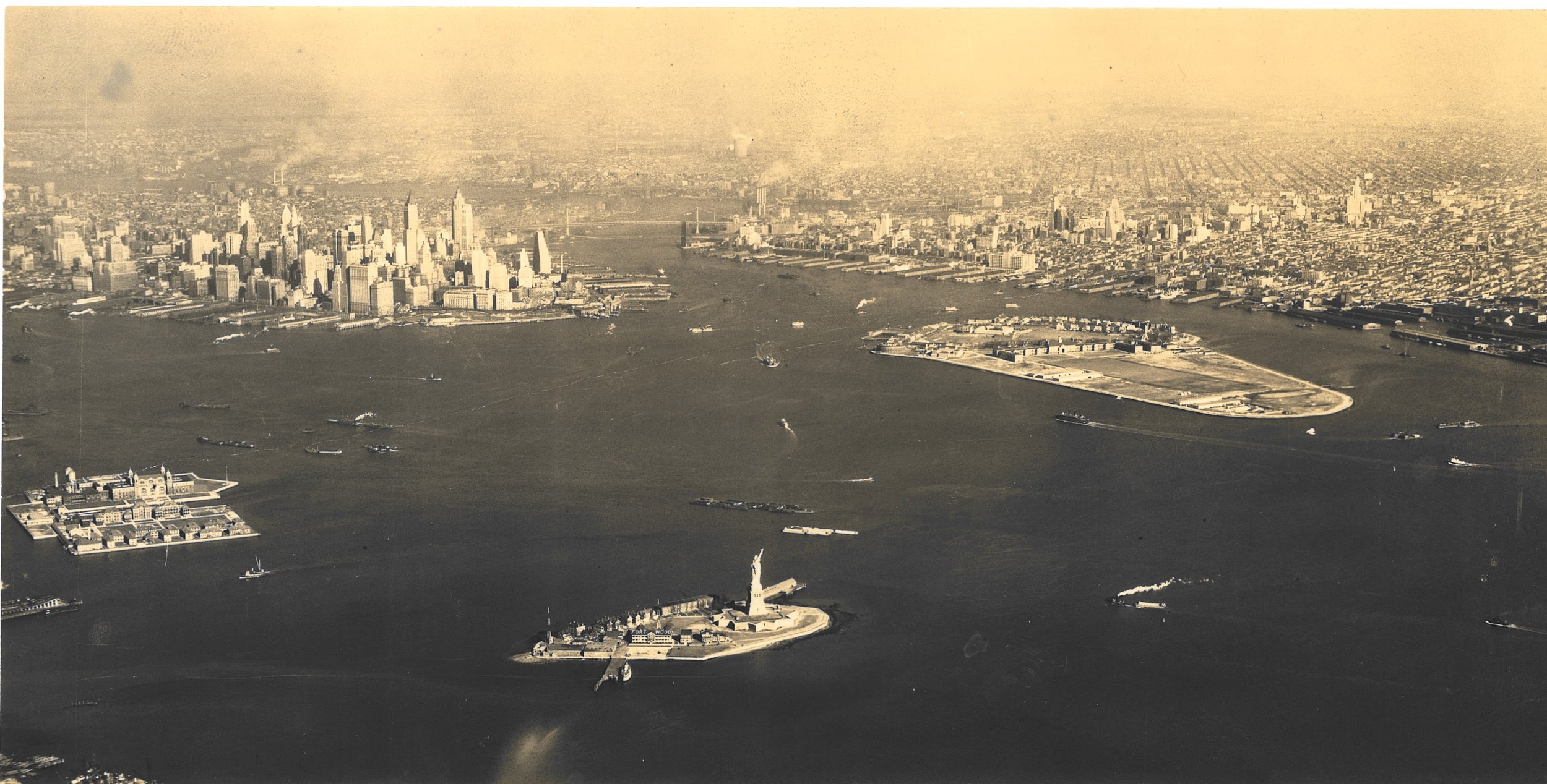
Aerial view New York Bay, Governor's Island, Statute of Liberty, Ellis Island, Manhattan and Brooklyn, ca. 1937. Photograph from 2nd Air Base Squadron Photo Section, GHQ Air Force, U.S. Army, Mitchel Field, New York, via WPA Federal Writers’ Project Photograph Collection. NYC Municipal Archives.
New York City is an archipelago of islands. New York harbor has 65 square miles of inland waterways and 772 miles of direct shoreline of which 580 miles surround the five Boroughs.
The city’s waterways—rivers, bays and ocean—provided food for the indigenous population and early colonists. The deep ice-free waters of New York Harbor served as the basis for the city’s economic growth and development for more than three centuries. But there was a cost; the maritime activities that generated jobs and wealth, also created pollution that degraded marine life and cut off access to the waterfront. Policymakers focused on the condition of the harbor for decades.

The Department of Docks photograph collection includes numerous large-format glass-plate negatives dating from the 1870s that depict the commercial activity along both the East and North (Hudson) River waterfronts. West Street, ca. 1870. Department of Docks Collection. NYC Municipal Archives.
Government recognized that encroachments and waste in the harbor required control but faced challenges in regulating emissions and shoreline construction.
Beginning with the publication of Silent Spring by Rachel Carson in 1962, Americans began focusing on environmental issues. The Cuyahoga River famously caught fire in 1969 leading to the eventual passage of the federal Clean Water Act in 1972. By the 1970s, the city and surrounding communities began to address these concerns with an increased focus on eliminating the discharge of raw sewage and toxic waste into area waterways. Since then, many fish species have returned, and as commercial activities diminished, waterfronts have been reclaimed for housing, recreation and other activities.

Graphic showing relationship between bathing beaches and sewage discharge from the Metropolitan Sewage Commission of New York’s 1912 report. NYC Municipal Library
More recently, climate-change and the resulting superstorms and other destructive weather events have focused attention on the waterfront and the benefits of habitat restoration and stormwater management. The Municipal Archives and Library collections include extensive historical documentation of the waterfront that may prove useful in this essential work to create a more resilient New York and New Jersey harbor.
The archival records date from the earliest years of the Department of Docks (1870– 1897); Docks and Ferries (1898 -1918); Department of Docks (1919-1942); Marine and Aviation (1942-1977); Ports and Terminals (1978-1985), through its final iteration, the Department of Ports and Trade (1986-1991). These series offer hundreds of cubic feet of maps, surveys, official correspondence and photographs.

Illustration from the report, Present sanitary condition of New York Harbor and the degree of Cleanness which is necessary and sufficient for the water issued in 1912. NYC Municipal Library.
Publications in the Municipal Library document research developed by government agencies. The Metropolitan Sewage Commission of New York, issued several reports on water quality and pollutants in the Harbor beginning in 1910. More recently, the Department of Health issued Beach and Harbor Water Sampling reports that showed levels of contaminants at City beaches. In 1926, the Board of Estimate’ Subcommittee on Main Drainage issued a report on tidal currents in the Harbor, based on the movement of bottle floats.
The theme of this year’s City of Water Day is to expand the capacity of New York and New Jersey communities to address climate change. Activities in the region include kayaking, rowing, hands-on workshops, and dozens of events for fun, education, and access to the waterfront. Visit the City of Water Day website for a complete calendar of events.
In the meantime, here are some historical images of New York’s waterfront.

The Department of Marine and Aviation collection includes large format color transparencies. Pier 40: Norwich and Stonington Lines (New England). Holland-American Lines (new Pier 40), circa 1960. Department of Ports and Trade Collection. NYC Municipal Archives.

Aerial view of the Brooklyn waterfront near Atlantic Avenue, September 19, 1956. Department of Marine and Aviation Collection. NYC Municipal Archives.

Aerial view of lower Manhattan, September 19, 1956. Department of Marine and Aviation Collection. NYC Municipal Archives.

North River piers, Chelsea section, July 24, 1953. Department of Marine and Aviation Collection. NYC Municipal Archives.

Barges, East River, June 30, 1938, Photographer: E.M. Bofinger WPA Federal Writers’ Project Photograph Collection.