New Amsterdam

Anniversary of Wall Street

The 13th of March marks another important anniversary in the history of New Amsterdam. For on March 13, 1653, less than two months after New Amsterdam formed its first municipal government, it faced an existential threat. The 1st Anglo-Dutch war had broken out in late 1652, and word had reached Governor General Petrus Stuyvesant and the council of Burgomasters and Schepens that English troops were amassing in New England for a possible overland invasion from the north. From the records of New Amsterdam:

“Upon reading the letters from the Lords Directors [of the Dutch West India Company in Amsterdam] and the last received current news from New England concerning the preparations there for either defense or attack, which is unknown to us, it is generally resolved:

First. The burghers of this City shall stand guard in full squads overnight…

Second. It is considered highly necessary, that Fort Amsterdam be repaired and strengthened.

Third. Considering said Fort Amsterdam cannot hold all the inhabitants nor defend all the houses and dwellings in the City, it is deemed necessary to surround the greater part of the City with a high stockade and a small breastwork….”[1]

From the 13th to the 19th of March 1653, they discussed the plans for defense and how to bid out the work. And on the 17th, someone, possibly even Stuyvesant himself, drew a little sketch in the margins of the court record of a cross-section of the defenses, consisting of a ditch, embankment and palisade wall. The wall built by the spring of 1653 to defend against the English would eventually give its name to Wall Street (although the Dutch called it Het Cingel, the Belt). All of this I have covered thoroughly in past blogs, but a few new questions have arisen concerning the history of the wall.

Court minutes from March 17th, 1653. The sketch of the wall is in the margin in the middle. Records of New Amsterdam, NYC Municipal Archives.

Diagram of the proposed wall from the Court Minutes of New Amsterdam, March 17, 1653. Records of New Amsterdam, NYC Municipal Archives.

The exterior has an embankment and a ditch, and the line projecting from the top of the wall may be a fraise, small sharp sticks to impede scaling the wall. The Dutch reads: “9 feet above ground, 3 feet in ground.” One dot = one foot. In the end a palisade proved too costly, and they used slats across posts set 15 feet apart.

A recent Bowery Boys podcast about the wall kindly directed listeners to my earlier blogs. However, one part of the story intrigued/stumped me. They reference an earlier wall built in 1644 near the end of Governor Kieft’s war with the native tribes. Was it possible that the wall really was built to defend against attacks by the natives and not the English? This blog explores that possibility and raises new avenues for exploration. The language quoted in these records obviously reflects the viewpoints of the Dutch colonial government. The Municipal Archives plans to add new content to New Amsterdam Stories by 2024 describing colonization from the perspectives of the original Munsee Lenape inhabitants and enslaved peoples to coincide with the 400th anniversary of Dutch settlement on Manhattan. These long over-due stories were originally planned when the website was launched, but the relocation of our offsite collections and COVID disrupted these plans.

The source for the 1644 wall claim is a Curbed New York article that references an article in Harper’s magazine “The Story of a Street,” from 1908, by Frederick Trevor Hill. In it, Hill wrote that on March 31, 1644, Kieft ordered a barrier to keep in stray cattle and defend against Native Americans. Hill was a lawyer and historian, and his enjoyable, but rather fanciful, article does get some things right, like this footnote:

“About this time (1655-6) the residents of Pearl Street, inconvenienced by the high tides, caused a sea wall to be erected, and the space between this barrier and their houses to be filled in, making a roadway known as De Waal, or Lang de Waal. Incautious investigators have confused this with Wall Street, and their error has resulted in some astonishing ‘history.’”

Very true. Since he was correct about this, his 1644 claim bears investigating. For the original source we need to go to records in the New York State Archives:

“31st of March [1644]

Whereas, the Indians, our enemies, daily commit much damage, both to men and cattle, and it is to be apprehended that all of the remaining cattle when it is driven out will be destroyed by them, and many Christians who daily might go out to look up the cattle will lose their lives; therefore, the director and council have resolved to construct a fence, palisade, or enclosure, beginning from the great bouwery to Emmanuel’s plantation. Everyone who owns cattle and shall desire to have them pastured within this enclosure is notified to repair there with tools next Monday morning, being the 4th of April, at 7 o’clock, in order to assist in constructing the said fence and in default thereof he shall be deprived of pasturing his cattle within the said enclosure.”[2]

Already the claim starts to fall apart, as what is described is a cattle pen not a defensive wall. The main concern seems to be that cattle would wander up-island when put out to pasture, which was dangerous for the cattle and for colonists who were in the woods looking for them. Earlier records scold colonists for letting their cattle trample the maize fields, which caused conflict with the Lenape and hurt the supply of grain for the colonists. Incidentally, the next two passages in the state records are notices of the peace treaties signaling the end of the war.

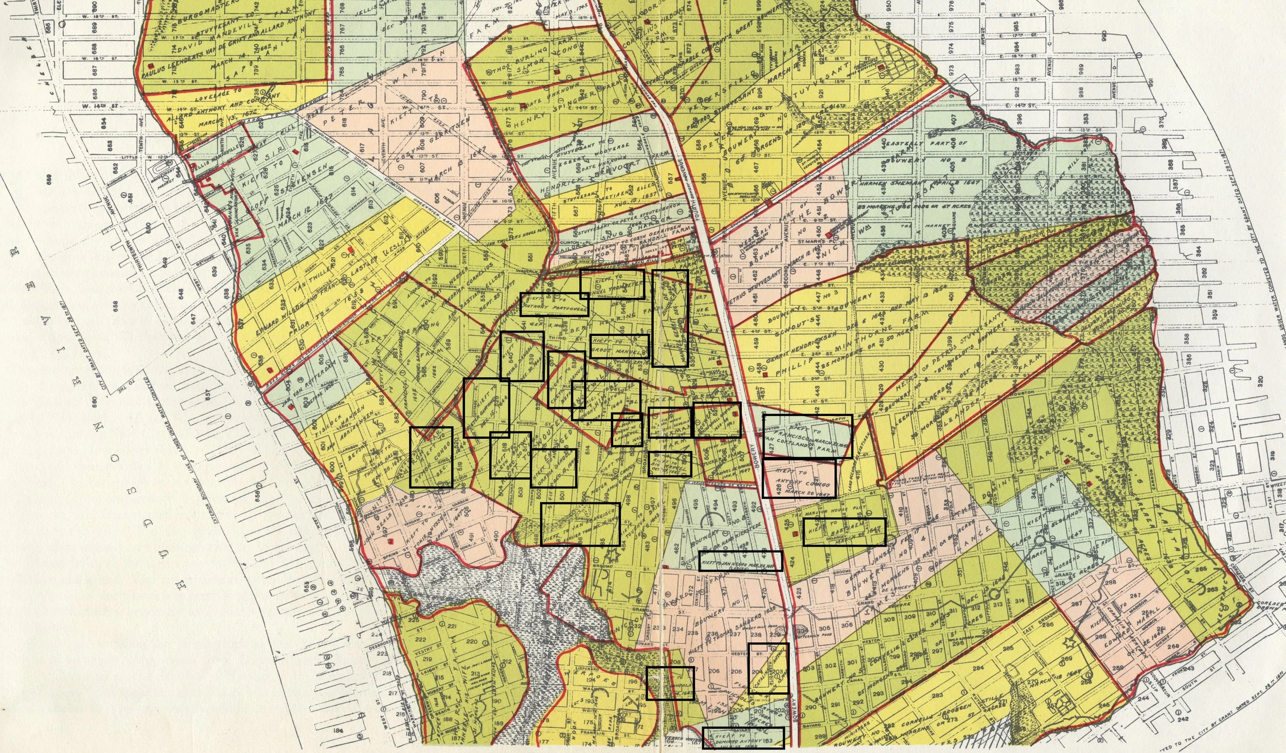
So not a wall, but where was this cattle fence? Hill thought it ran from “William Street… to what is now Broadway, and possibly from shore to shore, marked the farthest limits of New Amsterdam, as it then existed, and practically determined the location of Wall Street.”[3] Hill then went on to colorfully describe Stuyvesant in 1653 “stumping along the line of Kieft’s old cattle guard, seeking an advantageous location for the Palisade…” and placing it “some forty or fifty feet south of the old barrier and practically parallel to it….”[4]

Map of the Original Grants of village lots from the Dutch West India Company to the inhabitants of New-Amsterdam, (now New-York), lying below the present line of Wall Street, grants commencing A.D. 1642. Map created by Henry Dunreath Tyler, ca. 1897. Courtesy New York Public Library. Hill may have seen this map produced 10 years before his article, for he thought the cattle enclosure started east of the Sheep Pasture, and extended to Broadway, but there are no patentees on this map named Emmanuel.

Was this really the correct location? According to the original 1644 records, the enclosure was to run from “the great bouwery to Emmanuel’s Plantation.” Bouwerie is Dutch for farm, and the street now named Bowery was indeed the road that led to tracts of Dutch farmland. The “Great Bouwery” most likely referred to the large tract of Company farmland that ran from Bowery Street to the East River, later to become Stuyvesant’s farm, but all these large farms were north of present-day Worth Street. And where was Emmanuel’s Plantation? Historian I.N. Stokes identified Emmanuel as Emmanuel Pietersen. No map shows the exact location of his farm, but Stokes notes that Emmanuel was previously known as Manuel Minuit, perhaps because he had been enslaved by Pieter Minuit, founder of New Amsterdam.[5]

The large Dutch farms were located east of Bowery [the dashed line from point 4 to 16] in what would now be the East Village and Lower East Side. The “Great Bouwery” is number 1 on the map just above #16 (the Brewery). The key says “No1 Comp Bouwery met Een Traffelleyck Huys” [Company’s Bouwery with an excellent house]. Eventually this would become Stuyvesant’s farm. The farms given to freed Blacks in 1644 likely stretched from numbers 9 to 10 on this map. Jan Pietersen’s Plantation (#9) was just above Spring Street near Minetta Creek. It is possible Emmanuel had worked this land and was given the northern portion. Manatus Map [detail], 1639. Courtesy Library of Congress.

Key to the Manatus Map, 1639. Courtesy Library of Congress.

Less than two months before the fence ordinance, on February 25th, 1644, the Dutch West India Company resolved the petition of ten enslaved men who were demanding their freedom. They were granted conditional freedom for themselves and their wives, but not for their children who remained enslaved to the Company. The Company gave them farmland north of the town that had been abandoned by white settlers during Kieft’s war. The area became known as the Land of the Blacks, and eventually remnants of it were called Little Africa. Emmanuel was not one of the ten men, probably having gained his freedom earlier, but he would later marry Dorothy Angola, the widow of Paulo Angola, one of the ten. Together, Dorothy and Emmanuel merged their farms and successfully petitioned for the freedom of Dorothy’s adopted son Anthony in 1661.

Map of the Herring Farm from 1869. Manhattan Farm Maps, NYC Municipal Archives. The corner of the property in the middle of Washington Square Park is where the Lenape path that became Old Sand Road intersected with Minnetta Creek. Stokes says these formed the border of the cattle enclosure.

The vertical line shows the path that would become known as Bowery Road, but was originally the same up island trail that was incorporated into Broadway. The path westward to the Hudson River became known as Sand Hill Road until it crossed Minetta Creek, and still exists past that point as Greenwich Avenue. Stokes thinks the 1644 cattle fence followed this path from Bowery to Minetta Creek. These paths connected Lenape villages, farms and hunting and fishing grounds. From Indian paths in the great metropolis by Reginald Pelham Bolton, published by the New York Museum of the American Indian and Heye Foundation, 1922.

All of this is fascinating history, but is this anywhere near Wall Street? No, it is not. It is in what are now the East and West Villages. Stokes suggested the cattle fence “ran west from the Bouwery Road, along ‘the old highway’ (the Sand Hill Road), as far as Minnetta Water, where the bridge crossed the road to Sapocanikan…. Then westerly along the line between the later Warren and Herring farms to Emanuel’s land (near the corner of West Third and Macdougal Sts.).”[6] This is a bit confusing, but Sand Hill Road was an old Lenape trail that “commenced at the Bowery, and ran across that part of the city now known as Waverley Place, on the north side of Washington-Square, then Potter’s Field…”[7] The eastern bit of this road still exists at Astor Place and Greenwich Avenue preserves its western terminus. “Minnetta Water” was a fresh water stream now buried under Minetta Street. It originally flowed from around Union Square southwest to the Hudson River and would have formed a natural border for the enclosure. The line described by Stokes can be seen on a map of native trails, and on the farm map above as the northern border of Herring Farm. And lastly, Sapohanikan was a Lenape fishing settlement on the other side of Minetta. Although the Dutch had violently pushed the Lenape out by 1644, the area known as Greenwich Village (Greenwijck in the original Dutch) was still called Sapocanikan until the English colonial period.

Sanitary & Topographical Map of the City and Island of New York (1865) by Egbert Ludovicus Viele. Courtesy New York Public Library. Minetta Creek ran through Washington Square and determined the border of the Herring Farm. A remnant of Sand Hill Road can be seen above Washington Square Park and at Astor Place in this map. In 1644 ten formerly enslaved men and their wives were given land grants south of this area.

Why was Hill so convinced the location of this pasture was so much further south? Perhaps he was confused by an 1897 map showing a marshy sheep pasture within the City limits in 1642, along with the original Dutch land grants. But there are no grantees named Emmanual shown on this map, nor any great farm. The name Emmanuel or Manuel is not Dutch, but it was a common name amongst many of the early enslaved Africans in New Amsterdam, suggesting that they had been seized from Portuguese or Spanish ships or were from Portuguese colonies in West Africa. Although there were other Manuel’s recorded in 1644, all of them were part of the group of freemen given properties in the Land of the Blacks.

This finally brings us to one more recent online myth about the wall, that part of the reason for its construction was to keep out the freed black colonists north of the wall. Perhaps the origin of this concept was the close timing between the February 1644 land grants and the March 1644 “fence” construction, but as we now see not only was this 1644 project not a wall, but if Stokes is right, it also ran right across the Land of the Blacks, with most of the farmland south of the fence.

New scholarship may reveal more definitive answers, but unless new information comes to light, March 13, 1653 remains the birthday of Wall Street.


After publishing this blog another reference to the fence turned up while trying to find the location of Emmanuel’s plantation. In D.T. Valentine’s 1866 Manual of the Corporation Council, writing about the lands given to freed Blacks in 1644 he writes:

“We find, as further corroboration of the idea that the negro settlement was designed as an outpost, the fact that in the same year a great inclosure was established in the center of the negro settlements for the protection of the cattle of the whites. It had been a prominent object in the economy of the newcomers to increase the number of domestic animals, and for that purpose they were allowed to run at large through the forests covering the island, insomuch that at a much later period it is recorded that the woods were filled with animals almost as wild as when in their native condition. They were yearly driven by a grand turn-out of the cattle proprietors into an inclosure for the purpose of branding the yearlings, when they were all set loose again. The Indian troubles required more careful herding of the cattle than that alluded to, and hence, by resolution passed in the Provincial Council in 1644, it was decided that a clearing be made on Manhattan Island, extending from the Great Bowery (afterward Stuyvesant’s) to Emanuel’s plantation (Manuel the negro); and all inhabitants who wished to pasture their cattle within the clearing, to save them from the Indians, were required to appear by a certain day to assist in building a fence around the same.”

Valentine was not great in citing his research, but further evidence of the location of the 1644 cattle fence.


[1] Fernow, Berthold, The Records of New Amsterdam from 1653 to 1674, vol. 1, pp. 65-66

[2] Van Laer, Arnold J.F., New York Historical Manuscripts, Dutch, v. 4, p.216

[3] Hill, Frederick Trevor, “The Story of a Street,” Harper’s Monthly Magazine, 1908, p. 688

[4] Hill, p. 690

[5] Stokes, I.N., Iconography of Manhattan Island, v.6, p.76

[6] Stokes, v. 6, p. 76

[7] Ibid, v. 6, p. 50

A Charter for New Amsterdam: February 2, 1653

This week, For the Record recognizes a little-known, but significant anniversary in the history of the City of New York: February 2, 1653.

In 1977, City Council President Paul O’Dwyer successfully campaigned to have the date on the flag of New York City changed from 1664 (the year of the English takeover) to 1625, the year that the Dutch West India Company (the Company) directed a fort and settlement to be built in lower Manhattan. However, although the settlement in lower Manhattan was called New Amsterdam, it would be many years before it became a place that the Dutch would recognize with a separate municipal government.

View of New Amsterdam ca. 1653, copy of a 17th Century painting for I.N. Stokes, Iconography of Manhattan Island, vol. IV plate 9, NYC Municipal Library.

When General Petrus Stuyvesant arrived on the shores of Manhattan in 1647, the Dutch colony of New Netherland was in crisis. The prior Governor, Willem Kieft, was reviled and had been recalled to Holland after starting a brutal and disastrous war with the native peoples. Stuyvesant had been sent to restore order to the colony and reassure the colonists.

Stuyvesant asked the people of New Netherland to select eighteen representatives from whom he created an assembly of Nine Men.[1] The lawyer Adriaen van der Donck would later join the assembly and take a presiding role. Van der Donck soon set about gathering complaints from colonists to send to Holland. Stuyvesant forbade this and when the members continued to meet in secret, he had van der Donck arrested. Eventually van der Donck was released and he drafted a remonstrance, which he and two other members took to Amsterdam to present to the Dutch legislative body the States General. Amongst their demands was a call for a municipal government for New Amsterdam. They had little success at first but van der Donck’s 1650 publication, Vertoogh Van Nicuw Nederlandt, attracted public interest in the colony and raised concern that it was being mismanaged. Fearful that they might lose control over the colony, the Company eventually relented. On April 4, 1652, the Directors informed Stuyvesant via letter that he could form a municipal government with a schout, two burgomasters, and five schepens. Roughly analogous to a sheriff, two mayors and five city councilmen, but the burgomasters and schepens served as the lower court of justice as well as city administrators.[2]

The first page of a letter written by Jacobus Kip, first secretary of New Amsterdam, recounting Stuyvesant’s establishment of New Amsterdam’s government on February 2nd, 1653 as instructed by the Dutch West India Company on April 2, 1652. Kip probably sent this document in 1656 to the Company, where Hans Blumenthal, a director in Amsterdam, made his own copy. Both documents ended up in the Blumenthal papers at the New York Public Library. Reproduction from I.N. Stokes, Iconography of Manhattan Island, vol. IV plate 9. NYC Municipal Library.

Stuyvesant had received word by June 1652 that he could establish a city government, but waited until February 2nd, 1653, Candlemas Day. In Amsterdam, this was the day the Burgomasters and Schepens traditionally took their oaths of office. On this day he issued a lengthy document (a copy of this document is in the New York Public Library) that related how the Directors in Holland would “favor this new and growing city of New Amsterdam and the inhabitants thereof with a court of justice, to be constituted as far as possible… according to the laudable custom of the city of Amsterdam, name-giver to this newly developing city.”[3]

The new court was given legislative authority “between the two rivers to the Fresh Water [the pond at around Worth Street]” but in matters of criminal justice their authority extended the whole of the island and included “the inhabitants of Amersfoort, Breuckelen and Midtwout,” Dutch towns in present-day Brooklyn. The burgomasters were also charged with “alignment of houses, streets and fences… in an orderly fashion,” and developing any needed public buildings “such as churches, schools, a court house, weigh house, charitable institutions, dock, pier, bridges and other similar works….” And also, the ability to designate public officers such as “orphan masters, church masters, surveyors, fire wardens” as the need would arise. It was not quite the representative government that we think of today, but it was the start of the municipal government of what would become New York City.

The court minutes of New Amsterdam start with a prayer on the left page, and then on the right page the clerk recorded the first day of court on February 6th, 1653. Records of New Amsterdam, NYC Municipal Archives.

The Records of New Amsterdam in the Municipal Archives [minus some earlier ordinances issued by Stuyvesant] start a few days after the charter was issued, with a prayer for divine guidance. Some of the sentiments do not age as well as others, but this passage seems timeless: “Let us remember that we hold Court, not of men, but of God, who sees and hears everything. Let respect of person be far from us, so that we may judge the poor and the rich, friends and enemies, inhabitants and stranger according to the same rules of truth and never deviate from them as a favor to anybody, and whereas gifts blind the eyes of the wise, keep our hearts from greed, grant also, that we condemn nobody lightly or unheard, but listen patiently to the litigants, give them time to defend themselves.”

The prayer is undated but was probably written on the 2nd or on the first day of court, the 6th, because the next page starts with this:

“Thursday, February 6, 1653… Their Honors, the Burgomasters and Schepens of this City of New Amsterdam, herewith inform everybody, that they shall hold their regular meetings in the house hitherto called the City tavern, henceforth the City Hall, on Monday mornings from 9 o. c, to hear there all questions of difference between litigants and decide them as best as they can. Let everybody take notice hereof. Done this 6th of February, 1653, at N. Amsterdam.”

The most important feature of this lower court was that any person, male or female, could petition the court, citizen, and non-citizen alike. These court records form the backbone of the Dutch records held by the Municipal Archives and are part of a record of municipal government that extends until today.

The city tavern was renamed the City Hall, the Stadt Huys in 1653. It stood at the corner of what is now Broad Street and Pearl. George Hayward for I.N. Stokes, Iconography of Manhattan Island. NYC Municipal Library.


The government of New Amsterdam was formed when the Dutch were at war with the English. In March 1653, concerned over tensions with the English to the north, the court ordered a wall built to protect the colony. To learn more about the history of the wall that became Wall Street go to New Amsterdam Stories.

What did it mean to be a citizen of New Amsterdam? In 1657 the question was answered with the establishment of the burgher right – essentially city citizenship. To learn more, go to New Amsterdam Stories.


[1] Historical Society of the New York Courts, “The Nine Men and the 1649 Remonstrance of the Commonality of New Netherland” https://history.nycourts.gov/about_period/nine-men/

[2] See also, Russell Shorto, The Island at the Center of the World.

[3] Seymann, Colonial Charters, Patents and Grants to the Communities Comprising the City of New York. P. 177-189.

From Marketfield to the Greenmarket, Part I

Supplying a diverse and teeming city with fresh food has been a constant problem in New York. Farmers’ Markets, which have undergone a resurgence in recent years, are nothing new. In the early days of New Amsterdam, farmers and Native Americans simply brought their crops to town and set about hawking them, usually along the bank of the East River, known as the Strand. While references exist as early as 1648 to “market days” and an annual harvest “Free Market,” the process was unregulated and inefficient. Peter Stuyvesant, the Director General and the Council recognized this….

The Design for the Seal of the City of New York

Recently the question of whether the City’s seal has outlived its useful life circulated in the media. The seal is omnipresent on letterhead and other documents issued by City government agencies and officials. While news stories date the current seal to a local law enacted in 1915, the imagery dates back much further. The Municipal Library’s Vertical Files (so called because they consist of file folders of media releases, news clippings and other material held in vertical file cabinets, not shelves) yielded a surprising quantity of material on the subject.

Camera art for the City Seal, NYC Municipal Library vertical files.

Camera art for the City Seal, NYC Municipal Library vertical files.

An interesting history of the City’s seal was published in 1915 in the American Scenic and Historic Preservation Society’s twentieth annual report. Titled “SEAL AND FLAG OF THE CITY OF NEW YORK” it traces elements of the seal to the City of Amsterdam in 1342 at which time William Count of Henegouwen and Holland “made a present to the Amsterdammers of three crosses on the field of the City’s arms.” Not just any crosses but “saltire” crosses which means a diagonal cross—shaped like an X, not a t, and sometimes called a St. Andrew’s Cross. 

City seals and flags are outgrowths from the coats of arms and banners that initially came into use around 1100 when helmeted knights fought in battle. Distinctive color and design were required to identify who was behind a given helmet. An entire craft, heraldry, evolved. This “practice of devising, granting, displaying, describing and recording coats of arms and heraldic badges is complicated.” There are many rules around the shapes, designs, colors, patterns, and division of the shield into halves, thirds, quarters, etc. There is a separate set of directions for identifying where an item should be drawn or placed, consisting of numbered locations within the shield and, most important for our purposes, four cardinal points: chief for the top, base for the bottom, dexter for the left and sinister for the right (in Latin, dexter means right, and sinister left, but the positions refer to the shield bearer’s perspective). The design of New York City’s official seal incorporates all of these practices.

Evolution of the City Seal, NYC Municipal Library vertical files.

One consistent feature on the New York City seal is the image of a beaver. The fur trade formed the basis of commerce for New Netherlands, including New Amsterdam and the beaver was the foremost symbol. Interestingly a beaver both had value as a commodity and as currency itself. In the Scenic Society’s report the author notes, “The intelligence and industry of these little animals, their ingenuity as house-builders and their amphibious character make them eloquent symbols also for the City of New York. So far as we know, the use of the beaver in the arms of New Netherland, New Amsterdam and New York City is unique in heraldry.”

Documentation on the ornamental cast-iron seals that decorated the old West Side Highway shows the evolution of the City’s seal. The Seal of the Province of New Netherland, adopted in 1623, is made up of two shields—the smaller contains an image of a beaver and the larger, which surrounds the smaller, consists of a string of wampum. It is topped by a crown and the outer border is ringed with the Dutch words for “Seal of the New Belgium.”  (Holland and Belgium were united at that time.)

In 1653, New Amsterdam developed a municipal government, the Burgomasters and Schepens, which petitioned the West India Company for its own seal, which was received in 1654. Once again, there were two shields. Arranged one atop the other with a beaver between them, the larger shield contained three saltire crosses. There was drapery above and a label with the words “Seal of Amsterdam in New Belgium” at the bottom.

Tracing of the seal of New Amsterdam, NYC Municipal Library vertical files.

Tracing of the seal of New Amsterdam, NYC Municipal Library vertical files.

Ten years later, the Dutch surrendered New Amsterdam to the English and the City was renamed New York, after the Duke of York. The provincial seal was centered around the coat of arms of the Stuarts and was encircled with the Latin words meaning “Evil to Him who evil thinks.”  There is a crown atop the shield and all is encircled by a laurel wreath. This is the only seal without the otherwise ubiquitous beaver. In 1686, the rights of the City were affirmed by Governor Dongan in the Dongan Charter which also provided for a City seal. In the center is a shield on which the sails of a windmill are arranged in a saltire cross. There are two beavers and two flour barrels alternating between the crosspieces of the windmill. On either side of the shield are human figures—on the dexter side a sailor holding a device for testing the depth of water; on the sinister, a Native American image.

After the British evacuated the City in 1783, the new government updated the 1686 City seal to remove the Imperial crown. Atop the shield they placed an image of an eagle standing on a hemisphere. It’s dated 1686 to commemorate the Dongan Charter and the words “Seal of the City of New York” are inscribed in Latin. Most of these design elements are present in the City’s seal (and flags) today.

Seal of the Office of the Mayor, NYC Municipal Library vertical files.

Sometimes the use of the City seal was contentious. Common Council minutes from 1735 address an apparent wanton use of the city seal without proper authorization and there was some concern that the Mayor was not providing the Council with use of the seal. The Council passed an ordinance that “lodges and deposits the common seal in the hands and custody of the Common Clerk” of the city—today the city clerk—and further banned alternative city seals. The ordinance restricted the use of the seal to actions taken by the Common Council or the Mayor’s Court.

A review of the archival records in the Office of the Mayor collection starting with the so-called “early mayors” shows that correspondence was not bedecked with official letterhead. In many letters the tops of the pages were blank. In other instances, the name of the agency writing the letter was hand written at the very top of the page, followed closely by the text of the letter, written in flowing cursive. That’s not to say that there wasn’t a City seal in use. But, its’ use was sparing, apparently deployed to certify some official documents, not run-of-the-mill correspondence. A case in point is an 1816 certificate issued by Mayor Jacob Radcliff certifying that a woman named Nancy, approximately 60 years of age, was a free woman and could travel. An embossed seal is embossed at bottom of the document. It bears all the elements of the seal in effect today.

In 1914, a group of former members of the Art Commission was appointed to provide an accurate rendering of the corporate seal of the City, and a design for a City flag. The various departments and boroughs had been using variations of the seal which created confusion about the provenance of official documents.

Based on the recommendation of this committee, in 1915 the Board of Alderman amended the City’s Code of Ordinances relating to the city seal, flags and decorations on city hall. The Aldermen re-established the 1686 seal as updated in 1784 and required it to be used for all documents, publications or stationery issued or used by the city, the boroughs and the departments. They made some minor style changes-the shape of the seal, the position of the eagle, etc. and also changed the date on the seal from 1686, the date of the Dongan Charter to 1664, the year the City was named New York.

It is in this legislation that a major error was made. Apparently the bill’s drafters were not versed in the heraldic arts. As a result, the cardinal directions of “dexter” and “sinister” were assigned as the names of the figures in each location. So the sailor holding a depth reading device was named “Dexter” for the left sided placement and the Native American figure placed on the right was named “Sinister.” How this happened is lost to history. One would think the high-profile former Art Commissioners would have sounded the alarm and corrected the error, which still exists.

In 1975, City Council President Paul O’Dwyer sought to change the founding date on the seal from the existing 1686 date marking the issuance of the Dongan Charter, to 1625 when the Dutch established New Amsterdam. The legislation also invalidated all former seals bearing the 1664 date.

As mentioned, not only is there a City seal, but each of the boroughs have separate seals or emblems dating to the colonial period. After consolidation of the Greater City in 1898, the boroughs continued to use these seals for various official purposes until 1938 when the Board of Estimate mandated that the seal of the City of New York would replace any previous seals that had been in use. Thereafter, the various seals were to be found on the borough flags and not on official documents. But the use of the seal continued to vex officials and in 1970, the Board of Estimate mandated that the seal of the City be placed on each letterhead and restricted the use of a gold seal to the Board of Estimate and the Vice Chair of the Council.

Seal of the Borough of Queens, NYC Municipal Library vertical files.

The flag for the borough of Queens was announced in 1948 after a design competition.  The three-paneled seal included a tulip commemorating the Dutch on the dexter side, a double Tudor rose documenting the English on the sinister side. The border consists of shells used as money “wampum.”  At the very top of there is a crown signifying that the borough was named for a Queen, namely Queen Catherine Braganza wife of England’s King Charles the Second.

According to an excerpt in the files from a 1925 history, “the Boroughs of Brooklyn and Queens, Counties of Nassau and Suffolk Long Island, New York 1609-1924” Brooklyn’s seal was established by the West India Company in 1664.  It consists of an image of the Roman goddess Vesta (equivalent to the Greek goddess Hestia) holding fasces—or bunch of rods and an axe bundled together.  Apparently, this reflected the colony’s agricultural status. The motto surrounding the seal translates to “unity makes strength” which in 1664 was an update from the 1556 motto on the coat of arms of William the Silent, Prince of Orange. When the Village of Brooklyn officially incorporated in 1817, the seal was adopted by the common council.

Seal of Staten Island, NYC Municipal Library vertical files.

The seal of the Borough of Richmond, aka Staten Island, has gone through several evolutions. The Dutch named the island after the “Staten General” of their legislature. One seal consists of two doves facing each other with the letter S (for Staten) between them and N YORK beneath their feet. Another early seal has a female figure gazing toward the water in which two ships sail, one purportedly Henry Hudson’s Half Moon. In 1970, the then- Borough President held a contest to develop a better emblem. The winner was an oval with waves surrounding an island with birds flying in the sky above and STATEN ISLAND written between the waves and the island. However, this design was not universally admired. The Staten Island Advance reported that current Borough President James Oddo redesigned the emblem in 2017 to incorporate elements of the woman gazing out on the Verrazzano Narrows as well as oystermen, a moon and stars.

The Bronx, by contrast, maintained its seal, adopting the coat of arms of Jonas Bronck who settled in the area in 1639. A sun rises from the sea and a globe topped by an eagle stands above it. The Latin motto under the shield translates to “do not give way to evil.”  This same design was the basis for New York State’s post- revolutionary coat of arms.

Brooklyn Markets Seal, NYC Municipal Library vertical files.

Brooklyn Markets Seal, NYC Municipal Library vertical files.

Notwithstanding this requirement that the City seal be use on all official materials, some agencies developed their own seals. In 1940, Mayor Fiorello LaGuardia announced the conclusion of a contest, with a $10.00 prize won by a high school student, to design a seal for the Department of Markets. The seal featured a scale, a bundle of wheat and two full cornucopias. More recently, the New York Police Department (NYPD) developed a seal described in the agency’s 1987 annual report. It’s a somewhat cluttered design with the names of the five boroughs creating an interior ring. The City seal is at the bottom and the upper portion includes the words Lex and Ordo (Law and Order). The scales of justice are balanced atop the fasce and what looks to be a rocket (but probably isn’t) explodes from the top.

NYC Housing Authority Seal, NYC Municipal Library vertical files.

NYC Housing Authority Seal, NYC Municipal Library vertical files.

Indexing the Dutch Records of Kings County

Nena Huizinga, a 4th year student at the Reinwardt Academie in Amsterdam, the Netherlands, has spent the last four months at the Municipal Archives indexing Dutch colonial-era Kings County town ledgers.

Manhattan’s Dutch heritage has been long-recognized and the records of New Amsterdam have been transcribed, indexed and published. Less well-known is the Dutch origin of the towns and villages in Kings, Queens, Richmond and Westchester Counties. The Municipal Archives collection includes records of many of these communities dating to the Dutch colonial era and we have begun preserving and making them available.

This past summer, Harmen Snel and Hans Visser of the Stadsarchief, Amsterdam, visited the Municipal Archives. They examined the Kings County Dutch ledgers and took notes for an index that will greatly enhance the records value to historians.

Nena Huizinga, a 4th year student at the Reinwardt Academie in Amsterdam, the Netherlands, has spent the last four months at the Municipal Archives indexing Dutch colonial-era Kings County town ledgers. Photograph by Matthew Minor.

Kenneth Cobb recently spoke with Ms. Huizinga about her project:

KRC: Tell me about your background and how you found out about the Municipal Archives.

NH: I had originally intended to major in Cultural Heritage at the Academie. In the third year we must choose a minor, and I chose Archival Studies which was partly taught at the Hogeschool van Amsterdam (HvA) and the Reinwardt Academie. I now plan to graduate this summer with a dual degree. My work at the Municipal Archives is to fulfill my internship requirement. I had been studying about Dutch settlements and influence around the world—in Australia, Canada and the U.S. and through Mr. Snel I learned about the indexing project at the Archives.

Town of Bushwick records entry from 1663. NYC Municipal Archives.

KRC: I understand that there are two parts to your assignment—indexing the Kings County Town ledgers, and mapping a plan for future collaboration between the various institutions in New York and the Netherlands that house Dutch colonial records. Let’s start with the first part of your work here. Tell me more about your assignment and what has been the biggest challenge?

NH: I am creating an index to nine ledgers in the Archives’ collection—three from the Town of Flatbush; two each from the town of Flatlands and New Utrecht; and one from Bushwick. They date from 1646 to 1849. The biggest challenge for me is reading the old Dutch language.

KRC: Is it true that the “old” Dutch language written in these ledgers is very different from modern Dutch and difficult to read?

NH: Yes, it is very difficult to read! Even the letters are different. This past summer, before coming to the States, I took a special course to learn how to read the old Dutch. I felt like a 5-year old learning to read again!

KRC: Are there entries or passages in the ledgers that stand out?

NH: For me, the references to Native-Americans are the most interesting. There are many mentions of Native-Americans in the books, but they are usually referred to as ‘savages’ or something negative like that, but every once in a while they would write out their names and I found that very moving.

KRC: What were the interactions between Native-Americans and the colonists about?

NH: Mostly about property—usually a dispute of some kind.

Names of the Native Americans are among others given in the Flatlands book page 19: “In dato juny anno sesthien hondert sesendaertich is ten overstaen van directeur en raden van Nieuw Nederlant vercocht en getransporteert door de indianen met namen: Tenkirau, Ketamun, Arrikan, Awachkouw, Warinckekinck, Wappittawaekenis, Ghettin.” Roughly translated: “In June sixteen hundredth and thirty-six in attendance of the director and councils of New Netherland sold and transported by the Indians with the following names: Tenkirau, Ketamun, Arrikan, Awachkouw, Warinckekinck, Wappittawaekenis, Ghettin.”

KRC: How do you go about indexing the ledgers?

NH: First, I read the text to determine what sort of document it is, such as deed, or will, or petition. Then I write down the names, interesting topics and geographical places, such as Middelwout (Midwout), Schoenmakersbrug (Shoemakers bridge) and Vlackebos (Flatbush). I try to add as much as possible, but in some cases the writing is hard to read or the pages are much too faded to make any sense of it. The index will be in alphabetical order and followed by the page numbers, using the surnames first, like so: van Ekelen, Johannes, 235.

KRC: And the second part of your assignment – the collaboration plan?

NH: Yes, I am also working on a report about all the Dutch colonial records that are located in various libraries and archives in this area. Here in New York City, I have visited the New-York Historical Society and Collegiate Church which both have Dutch records. And I traveled to Albany, where they have the records of New Netherlands. I also visited Historic Hudson Valley in Tarrytown, Westchester County.

My goal is to identify areas of interest and overlap between the repositories and conduct research on how to fund and set up a collaborative network like two in Europe: Netwerk Oorlogsbronnen and Europeana. I want to draw attention to the benefits that cooperation can bring. Who is it important to? What are the advantages and disadvantages of cooperation? And I will also discuss the importance of multiple perspectives and how that can be enhanced when working together with not only repositories that have Dutch colonial records, but, for example, to try and involve people from the Native American and the African American communities to show their perspectives in the records.

KRC: What part of the Netherlands are you from?

Records of slave births in the town of Bushwick, 1814. NYC Municipal Archives.

NH: I am from a small town in Friesland, a region in the north, by the North Sea—there are only 2,000 people in the town. It is a farming area where they grow potatoes, onions and sugar beets. I moved to Haarlem for school, where I’ve lived the past three years.

KRC: We have a “Harlem” here too. What are your accommodations in NYC?

NH: I am staying in a kind of student apartment on West 46th Street, in Hell’s Kitchen. As it turns out, most of the other students in the house are also Dutch.

KRC: Had you ever visited NYC before?

NH: No. This is my first time here. I only knew New York from television and movies.

KRC: How has the reality differed from what you imagined?

NH: Well, it is less glamorous than I thought. I was a bit shocked by all the homeless people. And the streets, especially in my neighborhood, are not so clean. But all the people and the architecture of the buildings is great. And I love the museums—I’ve been to the Morgan Library, Museum of Modern Art, the Met, the Museum of the American Indian, and the Museum of Natural History.

KRC: Have you seen much evidence of our Dutch heritage in the City?

NH: Not in Manhattan, but out in Brooklyn where I recently walked around, I saw it everywhere in the street and place names. I also visited Greenwood Cemetery to look for the Dutch families I found in the ledgers, and yes, there they were!

Ms. Huizinga’s index project has included Dutch-language portion of the following Town ledgers:

-         Flatbush 1007, 1679-1819

-         Flatbush liber A 1000, 1670-1708

-         Flatlands 4000, 1674-1831

-         Flatlands Bergen, 1677-1849

-         Bushwick deeds, 1660-1825

-         New Utrecht 2001, liber A, 1659-1831

-         New Utrecht Deeds, 1646-1653

-         Flatbush 1001 Liber AA, 1676-1682

-         Flatbush No.1, 1652-1708

Look for digital copies of the ledgers to be added to the on-line gallery soon and we hope to continue the indexing project after Ms. Huizinga returns home to the Netherlands.

The Colonial Old Town Ledgers Digitization Project

The New York City Municipal Archives recently applied for funding to digitize colonial-era ledgers selected from the “Old Town” records collection. These unique administrative and legal records, dating from 1645 through the early 1800s, document the Dutch and English colonial settlements in New York City, western Long Island, and the lower Hudson Valley. The project is part of a larger Archives plan to describe and provide online access to all records in the Municipal Archives from the Dutch and English colonial era through early statehood.

The Archives has already successfully completed digitization and provided on-line access to the Dutch records of New Amsterdam and the proposed project will expand this effort to include the earliest records of communities throughout the metropolitan New York City region.

“The Court Book and nothing else to be found therein, 1751.” Newtown, Book 1, Old Town Records, NYC Municipal Archives.

The ledgers chosen for digitization are the earliest records in the Old Town records collection. These records were created by European colonists in communities throughout the New York City region. Commissioned by the Dutch East India Company, Henry Hudson led the expedition to what is now New York City in 1609. In 1614, the area between the Delaware and Connecticut Rivers was designated the colony of New Netherlands. Ten years later the States General of the Netherlands created the Dutch West India Company awarding them a monopoly on trade over a vast domain from West Africa to Newfoundland.

The first colonists in New Netherlands arrived in 1624 at Fort Orange (near Albany). In 1626 other settlers came to Manhattan Island and named their community New Amsterdam. As more colonists arrived they established new settlements resulting in an archipelago of Dutch communities throughout what is now Brooklyn, Queens, Richmond (Staten Island), and Westchester.

Dutch conflict with England over boundaries and trade led Charles II of England to grant the colony to his brother James, Duke of York, in March 1664. New Amsterdam surrendered to the English on September 8, 1664, and was renamed New York. Though in 1673, the Dutch briefly reclaimed the colony, the Treaty of Westminster returned it to English control in 1674.

Bushwick Deeds from 1660 and 1661 issued by Petrus Stuyvesant. Old Town Records, NYC Municipal Archives.

The provenance of the Old Town records collection dates from consolidation of the modern City of New York on January 1, 1898. Previously, the towns, villages and cities within the counties of Kings, Queens (parts of which are now in Nassau County), Richmond and Westchester (parts of which are now in Bronx County) maintained their own local governments that each created records—legislative, judicial, property, voter, health, school, etc. These local governments were dissolved during the latter part of the nineteenth century, at first by annexation to the old City of New York (Manhattan), or the City of Brooklyn, and finally through the unified City consisting of the five Boroughs in 1898.

The Comptroller of the newly consolidated city recognized the importance of the records of the formerly independent villages and towns and ordered transfer of the Queens, Richmond and Bronx/Westchester ledgers to the central office in Manhattan. In August 1942, fearing that New York City would be a prime target for enemy invasion, the Comptroller packed the ledger collection into crates and shipped them to New Hampton, N.Y. for the duration of the war. The Archives received the records from the Comptroller in several accessions from the 1960s to the 1990s.

The bulk of the Kings County town and village records were acquired by the Kings County Clerk via annexation during the latter part of the 19th century. Beginning in the 1940s, James A. Kelly, then Deputy County Clerk of Kings County arranged that the “historical” records of the county be turned over to St. Francis College in Brooklyn Heights, “on permanent loan.” They were housed in the James A. Kelly Institute for Historical Studies at the College. While in the custody of the Institute the ledgers were microfilmed. In 1988, due to financial considerations, the College closed the Institute and the records were transferred to the Municipal Archives.

Of particular note are the records of the Gravesend settlement in Kings County. Granted to Lady Deborah Moody in 1645, it became the only English town in the Dutch-dominated western area of Long Island. Based on the frequency in which her name appears in the Gravesend Town records, it is clear that Lady Moody, a religious dissenter who fled England and later Massachusetts, took an active and intense interest all aspects of her community.

Patent for the town of Gravesend, given to Lady Deborah Moody and her followers, 1645. Old Town Records, NYC Municipal Archives.

The Old Town records consist of hand-written manuscripts bound in a variety of styles (single-section pamphlets, spring-back account-book, and case-bound ledgers, among others). They include town and village governing board and legislative body proceedings and minutes, criminal and civil court docket books, deeds and property conveyances, records of estate administration, and coroners' records.

The earliest records are written in mid-17the century Dutch which differs from modern Dutch. The records from the English colonial period are written in a combination of old Dutch and English. The materials also include non-contemporary (19th Century) manuscript translations and/or transliterations of the Dutch records.

Several unique characteristics of the New Netherlands/New York colony make its records important for understanding the origins of the American democratic system. From its earliest years, the colony was notable for its diversity. Unlike New England and Pennsylvania where religion played the dominant role, the New Netherland colony was founded as a commercial enterprise. The official religious denomination of the colony was the Calvinism of the Reformed Church, but the Dutch West India Company urged tolerance toward non-Calvinists to encourage trade and immigration. Among the religious groups in New Netherlands (and more or less tolerated) were Lutherans, Quakers, Anabaptists, Catholics and Jews. The colony actively recruited immigrants from Germany, England, Scandinavia, and France, and was the home of the largest number of enslaved Africans north of Maryland.

“Register of the children born of slaves after the 2nd day of July 1799, within the town of Flatlands in Kings County in the State of New York…” Old Town Records, NYC Municipal Archives.

One recent example of the type of research that will be facilitated by the digitization work is the New York Slavery Records Index project underway at the John Jay College of Criminal Justice (City University of New York). Impetus from the project came from the realization that the college’s namesake, John Jay, and his family, were prominent slave-holders. The index project will result in a searchable compilation of records that identify individual enslaved persons and the slaveholders, beginning as early as 1619, and ending during the Civil War. The John Jay researchers have started examining the Municipal Archives collection of manumissions and legal records.

The Municipal Archives has already described and digitized the New Amsterdam records, including the original manuscripts and their English translations documenting proceedings, resolutions, minutes, accounts, petitions, and correspondence of the colonial government. When the Old Town records phase is completed, historians will be able to explore how colonial New York legal institutions and practices served as a foundation for the judicial system and guaranteed freedoms of the new Republic and answer important questions about a formative time period in the nation’s history.

Future blog posts will describe project progress and highlight unique “finds” in this rare collection.