For Jane’s Walk (named after urban historian Jane Jacobs), the New York City Municipal Archives participated in two events, a tour of the Archival storage facility in Brooklyn, and a walking tour of lower Manhattan tracing the path of New Amsterdam. The tour will live on in an app, but you too can follow it virtually. The following is a transcript of the author’s tour.
The 1890 Police Census–Digitized
The Municipal Archives recently completed digitizing the 1890 Police Census. Supported by a generous grant from the Peck-Stackpoole Foundation, project staff reformatted all 894 extant volumes of the collection to provide access (113 volumes are missing from the collection). They re-housed the volumes in custom-made archival containers to ensure their long-term preservation. Long prized by family historians, the census provides unique documentation of approximately 1.5 million inhabitants of New York City. To further enhance access to the valuable information in this series, the Municipal Archives has invited anyone with an interest to participate in a transcription project.
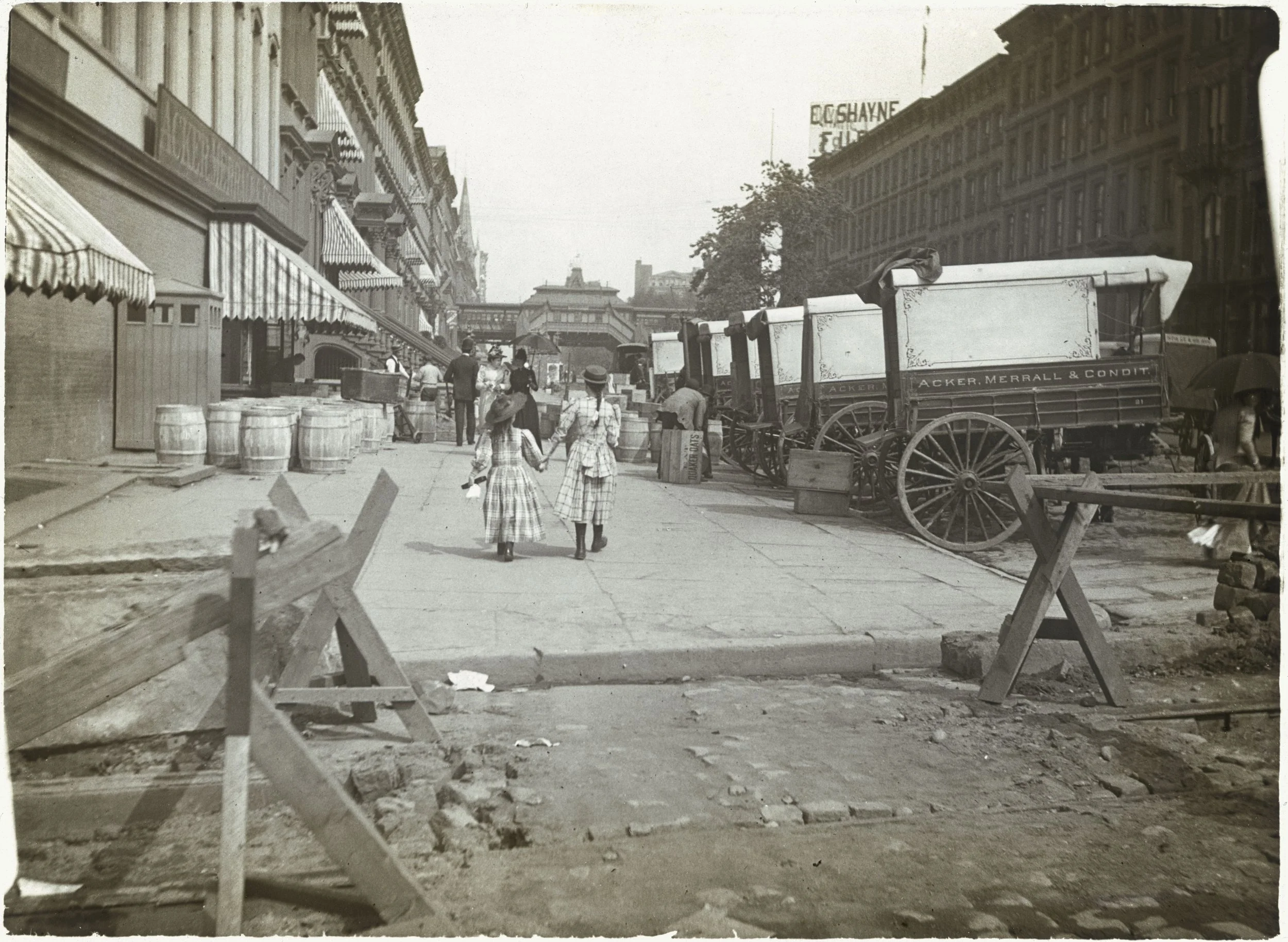
42nd Street, looking east to 6th Avenue Elevated, ca. 1890. DeGregario Family Collection, NYC Municipal Archives.
Provenance of the Census
“It is the right of the people of New York to be counted accurately and to have representation in Congress and in the Electoral College proportionate to their population. In their name, I demand as their right, that the federal authorities make an accurate enumeration of all the inhabitants of the City of New York.” Mayor Hugh Grant, October 16, 1890.
As it had done every ten years since 1790, federal census takers conducted an enumeration of the City in 1890. The count took place between May and June. New York City Mayor Hugh Grant and other city officials believed the federal census significantly undercounted inhabitants. To support their claim, Grant ordered the Police Department to conduct another census. It took place between September 29, and October 14, 1890. The new count showed a gain of 200,000 people in the population, compared to the federal number.
“Not Allowed”
Based on the results of his “police” census, Mayor Grant submitted a letter to the Superintendent of the Census in the Department of the Interior requesting a re-count. The Federal office refused. Grant submitted a second request; also denied. The Municipal Archives mayoral records from the Hugh Grant administration includes the lengthy correspondence from the Department of the Interior detailing their reasons for not conducting another census of the City. In his cover letter to Mayor Grant dated October 27, 1890, Interior Secretary John W. Noble concluded, “There is sent you herewith an opinion answering your demand for a renumeration of the inhabitants of your city, which, for reasons therein set forth, is not allowed.” Noble attached a fifteen-page document listing the reasons for declining to conduct another census.
Noble’s analysis included the statement that part of the difference can be attributed to the “...matter of common observation that many thousands of people of the City of New York give up their abodes in June of each year for vacation or recreation abroad or in the surrounding country, and many thousands more go to service with them...” Noble also observed “There is also a natural increase of population in one fourth of a year.” At that time, the arrival of new immigrants, many thousands per month, could account for the greater population recorded by the City in October, compared to the federal count in June. Mayor Grant’s second request resulted in another denial with a similar eight-page attachment.

Lower East Side street, ca. 1890. Department of Sanitation Photograph Collection, NYC Municipal Archives.
It is important for researchers to note that Mayor Grant’s outgoing correspondence in this matter will be found in the “letterpress” volumes. Maintained as a separate series, outgoing correspondence from mayoral offices during the latter part of the nineteenth century is in the form of carbon copies on thin onion-skin paper bound into volumes. There are approximately 160 volumes in the series; each volume is generally indexed by the name of the correspondent, or subject. Collection Guides provides further information and an inventory of the series.
The whereabouts of Mayor Grant’s “police” census within New York City government offices after 1890 is not known. Likewise, there is no documentation of when the Municipal Archives received the census volumes, but it has been part of the collection since at least the early 1970s. There is also no information about the 113 missing volumes.
The fate of the federal 1890 census is known, however. In 1921, a fire in the basement of the Commerce Building in Washington, D.C. damaged hundreds of thousands of pages. Although the charred pages were salvaged, in December 1932, the Chief Clerk of the Bureau of the Census submitted a record disposal application to the Librarian of Congress that included what remained of the 1890 census record. On February 21, 1933, Congress authorized destruction. [1]

High view looking north from 23rd Street up Broadway, ca. 1890. William T. Colbron, photographer. DeGregario Family Collection, NYC Municipal Archives.
The Digitization Project
In 2022, the Peck Stackpoole Foundation awarded the Municipal Archives a grant to determine the feasibility of digitizing the census collection. Based on productivity achieved during the pilot, the Foundation awarded a second grant in 2024 to complete digitization.
The Municipal Archives employed a digitization technician, Marie Cyprien, to complete the task. In accordance with Federal Agencies Digital Guidelines Initiative (FADGI) recommendations, Ms. Cyprien captured the images using an overhead camera. She converted the raw images to other formats via batch processing. She created preservation format TIFF files and applied file-naming standards according to Municipal Archives standards.
Completed in December 2024, digitization of the 894 ledgers in the 1890 New York City Police Census collection resulted in 77,844 images. Ms. Cyprien also completed the necessary collection rehousing into 39 custom boxes, barcoding, and labeling the volumes.
The 1890 Police Census

239 East 114th Street, home of the “Marks” family, with children “Leo and Adolph,” better known as Chico and Harpo, of the Marx Brothers. Julius, aka “Groucho” Marx, was just missed in the census as he was born at this address on October 2, 1890. 1890 census, NYC Municipal Archives.
The 1890 New York City Police Census produced 1008 volumes; 894 volumes are still extant. Each volume lists the population of one election district in New York County. A map of the election district boundary can be found on the last page of each volume. Prior to the consolidation of New York City in 1898, the boundary of New York County was contiguous with the island of Manhattan, plus annexed districts of what is now the Bronx. The 1890 census includes the western portion of the Bronx that was annexed in 1874, but not the eastern portion annexed in 1895. As Brooklyn, Queens, and Staten Island would not be boroughs of the city until 1898, they are not included in the census.
New York City police officers conducted the census. The handwritten entries record election district, assembly district, police precinct, name of the police officer/enumerator, and the address, name, gender, and age of each resident. There is no indication of the relationship of one person to another, occupations, or other demographic information.
Significance of the collection
Loss of the federal 1890 census makes the City’s version uniquely valuable in bridging the gap in demographic information between 1880 and 1900. Immigration to the United States surged during that period; in 1890, newcomers comprised 42 percent of New York City’s total population. The census is particularly useful in documenting children. Due to language barriers and differing cultural traditions, many families failed to report the births of their children to the City’s Health Department. The 1890 police census can be used to identify the names and approximate date of birth for the estimated 15-20 percent of children without civil birth records.
Next Steps
The Municipal Archives Collection Guides describes the census record and provides a link to the digital images. Interested persons are invited to visit From The Page for information about the recently launched project to transcribe and index the1890 census. Look for future For the Record articles that will describe how to use this essential research resource.
Department of Buildings - Manhattan Block and Lot Collection, 1866-1977
The Western Union Telegraph Company Building, 60 Hudson Street, Perspective of Hudson & Thomas Streets, May 29, 1928. New Building application 278 of 1928. Architects: Voorhees, Gmelin & Walker. Department of Buildings - Manhattan Block and Lot Collection, Block 144, Lot 33-56. NYC Municipal Archives.
For the researcher investigating the built environment of New York City, material contained within the Municipal Archives is a gold mine. Recent blogs have described three of these resources, the Assessed Valuation Real Estate Ledgers, the Manhattan Department of Buildings docket books, and the Manhattan building plan collection, part 1, and part 2.
This week’s subject is another series from the Department of Buildings Record Group (025)—the application permit folders, a.k.a. the block and lot folders. The series is a subset of the Department of Buildings Manhattan Building Plan Collection, 1866-1977 (REC 074).
Totaling approximately 1,230 cubic feet, the permit folders provide essential and detailed construction and alteration information for almost every building in lower Manhattan from the Battery to 34th Street. In addition, a wide range of historical subjects can be explored using these records including the effect of planning, zoning and technology on building design, the role of real estate development as a gauge of national economic trends, and the evolution of architectural practice, particularly during the period of professionalization in the latter part of the 19th century.
Established in 1862, the Department of Buildings (DOB) “had full power, in passing upon any question relative to the mode, manner of construction or materials to be used in the erection, alteration or repair of any building in the City of New York.” All DOB personnel were required to be architects, masons, or house carpenters. Then, beginning in 1866, New York City law required that an application, including plans, be submitted to the DOB for approval before a building could be constructed or altered.
The provenance of the collection in the Municipal Archives dates to the 1970s when the DOB began microfilming the application files and plans as a space-saving measure. They intended to dispose of the original materials after microfilming. The project began with records of buildings in lower Manhattan, proceeding northward to approximately 34th Street when it was discovered that the microfilm copies were illegible. The DOB abandoned the project and the original records were transferred to the Municipal Archives for permanent preservation and access.
NB Application 34 of 1890, page 1, for a “Nurse Building” to be appended to the Society of the New York Hospital at 6 West 16th Street. Architect: R. Maynicke for George B. Post. Department of Buildings—Manhattan Block and Lot Collection, Block 817, Lot 29. NYC Municipal Archives.
NB Application 34 of 1890, page 2, for a “Nurse Building” to be appended to the Society of the New York Hospital at 6 West 16th Street. Architect: R. Maynicke for George B. Post. Department of Buildings—Manhattan Block and Lot Collection, Block 817, Lot 29. NYC Municipal Archives.
Most applications are accompanied by a site plan showing the building’s location. Site plan for the “Nurse Building” at 6 West 16th Street. NB Application 34 of 1890. Department of Buildings—Manhattan Block and Lot Collection, Block 817, Lot 29. NYC Municipal Archives.
New Building (NB) Applications
In theory, there should be an NB application for every building constructed after 1866. Unfortunately, prior to the mid-1960s, DOB policy was to dispose of the files of buildings that were demolished. The result is that the Municipal Archives collection generally comprises only records of buildings extant as of the mid-to-late 1970s.
The NB application provides the most complete and detailed information about a structure. The form includes location (street address and block and lot numbers); the owner, architect and/or contractors; dimensions and description of the site; dimensions of the proposed building; estimated cost; the type of building (loft, dwelling factory, tenement, office, etc.); and details of its construction such as materials to be used for the foundation, upper walls, roof and interior. Every NB application was assigned a number, beginning with number one for the first application filed on or after January 1, up to as many as 3,000 or more by December 31, each year.
Specifications form, front NB application 222 of 1919, the Cunard Building, 25 Broadway. Department of Buildings—Manhattan Block and Lot Collection, Block 13, Lot 27. NYC Municipal Archives.
Specifications form, reverse, NB application 222 of 1919, the Cunard Building, 25 Broadway. Department of Buildings—Manhattan Block and Lot Collection, Block 13, Lot 27. NYC Municipal Archives.
As buildings incorporated new technologies such as elevators and steel-frame construction, the approval process became more rigorous, requiring more extensive information about the proposed structure. Permit folders for larger buildings often contain voluminous back-and-forth correspondence between the DOB examiners and the owners and architects. If any part of an NB application was disapproved the owner or architect was obliged to file an “Amendment” form stating what changes would be made to the application so that the building would comply with building codes.
Amendment to NB Application 44 of 1925, filed November 23, 1926 for the building at 35 Wall Street. Each point on the amendment explains how the architects were modifying their plans to meet DOB objections. (Note point no. 4. “The height of the Wall Street front has been altered to meet the requirements of the Building Zone Resolution—Article 3, Section 8. All setbacks have been clearly noted on elevations and setback plan.)” Department of Buildings—Manhattan Block and Lot Collection, Block 26, Lot 1. NYC Municipal Archives.
Correspondence from the Commissioner of the Department of Public Works in the Office of the President of the Borough of Manhattan, to the Department of Buildings regarding NB application 222 of 1919 (the Cunard Building at 25 Broadway), and possible disruption to sewers and sidewalks, August 21, 1919. Department of Buildings—Manhattan Block and Lot Collection, Block 24, Lot 27. NYC Municipal Archives.
Correspondence from the Zoning Committee to the Department of Buildings regarding the height of the Cunard Building, 25 Broadway, NB application 222 of 1919. Department of Buildings—Manhattan Block and Lot Collection, Block 24, Lot 27. NYC Municipal Archives.
When the DOB approved a NB application, they issued a permit and construction could begin. Periodically during construction, inspections would be made by DOB personnel and their reports would also be included in the application file.
Other Applications
After a building was completed and the final inspection report submitted, any subsequent work on the building would require a separate Alteration (ALT) application. As building technology became more complex, the DOB began to require separate applications for elevator and dumbwaiter installations, plumbing and drainage work, certificates of occupancy and electric signs. The permit files also contain numerous Building Notice (BN) applications pertaining to relatively minor alterations. The DOB also mandated a “Demolition” application to raze buildings. The permit files generally do not include documents related to building violations.

DOB building permit folder, Block 551, Lot 21, 26 West 8th Street. Department of Buildings—Manhattan Block and Lot Collection. NYC Municipal Archives.
The DOB organized all applications and related correspondence into folders according to the block and lot where the building was situated. After 1898, each block in Manhattan was assigned a number, beginning with number 1 at the Battery, and each lot within the block was also assigned a number. The original block and lot filing scheme has been maintained by the Municipal Archives for the block and lot permit collection. An inventory of the permit folder collection is available in the new online Municipal Archives Collection Guides.
The Municipal Archives has also maintained the original permit folders, whenever possible. The folder lists the application paperwork contained within and serves as a table of contents. If paperwork related to an application listed on the folder is missing, it is possible to trace at least basic information about the action using the DOB docket books as described in a recent blog Manhattan Department of Buildings docket books.
American Exchange Irving Trust Company, to the DOB, December 28, 1928, regarding application to the Board of Standards and Appeals. NB application 419 of 1928. Irving Trust Company Building at One Wall Street. Department of Buildings—Manhattan Block and Lot Collection, Block 23, Lot 7. NYC Municipal Archives.
Application for Variation from the Requirements of the Building Zone Resolution filed by the American Exchange Irving Trust Company, for One Wall Street, NB application 419 of 1928. Department of Buildings —Manhattan Block and Lot Collection, Block 23, Lot 7. NYC Municipal Archives. (N.B. The variance was approved.)
Building bulk calculation diagram submitted with Application for Variation from the Requirements of the Building Zone Resolution filed by the American Exchange Irving Trust Company, for One Wall Street, NB application 419 of 1928. Department of Buildings—Manhattan Block and Lot Collection, Block 23, Lot 7. NYC Municipal Archives.
The collection provides detailed data about specific buildings and enables the researcher to explore broader topics. For example, one theme of interest to architectural historians is the impact of New York’s 1916 zoning ordinance. The regulation had been imposed partly in response to construction of the massive Equitable Building on lower Broadway, but more generally to reduce the growing density of the built environment. It is usually argued that the law was responsible for the setback style of New York skyscrapers constructed throughout the 1920s. In an examination of the NB applications for several skyscraper buildings erected before the Depression, such as the Irving Trust tower at 1 Wall Street, it was found that very often the original NB application was disapproved, in part because the building plans violated some part of the 1916 zoning ordinance. In response, however, the architects did not revise their plans, but instead appealed to the City for a variance and invariably received permission to proceed with their original plans.
Application to convert a stable to a sculptors studio, ALT 531 of 1903, no. 26 West 8th Street / 5 McDougall Alley. Department of Buildings—Manhattan Block and Lot Collection, Block 551, Lot 21. NYC Municipal Archives.
The permit folder collection also provides ample opportunity for researchers to study the long tradition of adaptive re-use of buildings in lower Manhattan. Although many of the buildings in these neighborhoods pre-date establishment of the DOB, the collection is rich with applications submitted for later alterations, as architects, homeowners, and developers converted older structures into “modern” dwellings by removing stoops and covering facades with light-colored stucco, mosaic tile, and shutters.
Correspondence from architect Cass Gilbert to DOB, September 22, 1905. NB application 1376 of 1905, 90 West Street Building. Manhattan Block and Lot Collection, Block 56, Lot 4. NYC Municipal Archives.
The permit folders, along with the associated building plans, contain documentation for the study of individual architects, as well as architecture as a profession. Scholars will find an abundance of unique materials that detail the professionalization of the field, especially during the latter half of the 19th century.
Together with the Assessed Valuation of Real Estate ledgers, the several Department of Buildings series—docket books, architectural plans, and the permit folders, provide an unparalleled opportunity for detailed research on the built environment. Few other cities in the nation possess a body of documents whose scope and completeness can compare with these New York City records.
In the Details
In the summer of 2018, I began work at the Municipal Archives as the lead archivist on the Manhattan Building Plans Project, a much-anticipated, years-long undertaking to process and rehouse more than 100,000 architectural drawings that had been filed with the Department of Buildings between 1866-1977. The drawings had been transferred to the Archives from the Department of Buildings in the aftermath of a less-than-successful microfilming project in the late 1970s. The microfilming vendor, believing the original material was going to be disposed of, haphazardly and messily re-wrapped the plans in acidic paper. They tightly tied each “bundle” with damaging twine and labelled with minimal, and often insufficient, identification.
Pre-processing storage conditions of the Department of Buildings Collection, NYC Municipal Archives.
Post-processing (hooray!) storage conditions of the Department of Buildings Collection, NYC Municipal Archives.
My colleagues and I are processing and rehousing the plans to reestablish intellectual control over the material and to create more optimal retrieval and storage conditions. To do so, we un-roll the dusty bundles, identify the plans, sort, flatten, repair if damaged, count and catalog, carefully and neatly re-roll onto acid-free tubes, wrap with protective Mylar, and store in acid-free boxes.
We are organizing the plans according to BBL, or borough, block, and lot number, so that all the plans for all the buildings or structures built on a particular city lot, and all the changes and alterations made to an already existing building on that lot, are stored together. When sorting the plans, we verify the block and lot information and record it, as well as addresses, quantity of plans, dates, notes on architects, important features, and condition concerns. To date, we have processed and rehoused over 22,000 plans for buildings in lower Manhattan. They comprise all manner of architectural drawings—sections, elevations, floor plans, and details—as well as engineering and structural diagrams for every conceivable type of building—industrial, manufacturing, retail, financial, and residential. From stables to skyscrapers and everything in between.
Among the plans are obvious showstoppers, beautifully rendered elevations of well-known buildings splashed with color and architectural detail--what people think of when they think of historic New York City architecture. But most building plans are not that, and the vast majority of the tens of thousands of plans that we have viewed are far humbler and more mundane. They show alterations, fireproofing, elevator and boiler installations, signage, electrical work, and plumbing, plumbing and more plumbing. And they reveal a lot about the true nature of the building, the people who made and used it, and the city itself.
Wooden elevator shaft with dovetail detail, 129 Mercer Street, 1896. H.G. Knapp, architect. Department of Buildings Collection, NYC Municipal Archives.
When you look through 22,411 plans of the details of New York City, day in, day out, what catches your jaded eye? What are the small things that delight or confound you and make you stop for a moment and show your colleagues or take a photo with your phone to refer to later or simply to show a friend? For me these stop-and-look-closer moments seem to fall into three different categories:
1. The “Awww! Pretty!” Plans
Finding beauty in unexpected places has been one of the highlights of the project. To see the intricate parts of a building drawn in two dimensions provides a new perspective that gives you the ability to appreciate the complexity and precision of something as ubiquitous as a foundation or a column or a plumbing fixture in a brand-new way.
Surprisingly delicate rendering of a foundation pier for the Bowling Green Building, 11 Broadway, 1895. W. & G. Audsley, architects. Department of Buildings Collection, NYC Municipal Archives.
Complex column details from an 18-story loft building, 460 West 34th Street, 1927. Parker & Shaffer, engineers and industrial architects. Department of Buildings Collection, NYC Municipal Archives.
Two images showing the artistry of plumbing fixtures from two very different buildings. On the left is the plan for the barber shop basins at the former New York Life Insurance Building, 346 Broadway, 1895, McKim, Mead & White, architects.
And on the right a plumbing detail from the plans for the “City Prison” [aka the Manhattan House of Detention], 100 Centre Street, 1937, Harvey W. Corbett & Charles B. Meyers, architects. Department of Buildings Collection, NYC Municipal Archives.
2. The “Wait, what?” Plans
We process so many plans that you can’t take too much time perusing every drawing. But when a confounding phrase or image is spotted, you can’t help but look a little closer and do a bit of research. You can’t just let the Coloramas, movie theater train cars, and doughnut computers of the world pass you by.
Colorama display detail from a plan entitled “Colorama Room Plans and Traverse Sections, New Bank Entrance,” The Bank for Savings, 280 Fourth Avenue [now 280 Park Avenue South], 1953. Alfred Hopkins and Associates, architect. Department of Buildings Collection, NYC Municipal Archives. Coloramas were spectacular 18-foot by 60-foot color transparencies created by Eastman Kodak and displayed on the east balcony in Grand Central Terminal from 1950-1990. Only 565 were ever made and a few were later cut down in size and displayed elsewhere, which seems to be the case here. Department of Buildings Collection, NYC Municipal Archives.
Plan for alterations to theater interior, 46 East 14th Street, 1906. Department of Buildings Collection, NYC Municipal Archives. In the early 1900s the area around 14th Street had many nickelodeons and theaters competing for business. The Brady-Grossman Company featured Hale’s Tours, where patrons sat in simulated Pullman cars and watched films of picturesque railroad routes as if they were travelling. The “tours” became more and more sophisticated, with panoramas, sound effects, and a rocking motion making it feel like the “train” was moving; this seems to be an early version of the attraction.
Plan entitled “Additional Steel Support of IBM Units” for the Doughnut Corp. of America, 45 West 36th Street, 1954. J. Gordon Carr, architect. Department of Buildings Collection, NYC Municipal Archives. The Doughnut Corporation of America was founded in 1920 primarily to sell doughnut-making machines to bakeries. They later expanded to manufacturing doughnut mixes for home use as well as running a chain of coffee shops. They also founded the National Dunking Association in 1931 to encourage doughnut-eating. So it is really not too surprising that such innovators were also early adopters of the most modern (but heavy) technology.
3. The “That’s so cool!” Plans
There are some things that are just too fun not to pay attention to. Whether it’s a hand-drawn detail that shows a draftsman taking artistic liberties or a floor plan that proves New York City building façades could contain any and all sorts of interesting enterprises.
A charming drawing for Bear & Son clothing store near Union Square, 50 East 14th Street, date unknown. Note that the draftsman went to the trouble to write in “Bear’s Head” and “Cub’s Head” at the top. Department of Buildings Collection, NYC Municipal Archives.
Floorplan for the Julian Billiard Academy, 138 East 14th Street, circa 1933. Department of Buildings Collection, NYC Municipal Archives. This second-floor pool hall was owned by the same family for over 50 years and its closing in 1991 was felt by many New Yorkers to be a real blow for “old New York.”
Longitudinal section drawing for Ogden & Wallace Iron Warehouse, 583 Greenwich Street, 1893. John A. Hamilton, architect. Department of Buildings Collection, NYC Municipal Archives. Though many architectural drawings depict both exterior and interior elements, this is the only one we’ve seen with such a cozy (lit!) fireplace.
Alteration plan for Electric Lady Studios, 52-54 West 8th Street, 1969. Storyk Design, architect. Department of Buildings Collection, NYC Municipal Archives. Soundproofing and vocal booth construction details for the recording studio built for Jimi Hendrix in 1970 and still in demand today. Very cool.
And I’ll close with one of the first drawings that caught my eye and is still one of my favorites It spans all three categories. It’s a beautiful drawing of a beautiful object, its history certainly deserves some further research, and the structure is a cool, and recognizable detail of New York City architecture.
Tank and tower drawing for House of Relief, 67-69 Hudson Street, 1912. Felber Engineering Works. Department of Buildings Collection, NYC Municipal Archives.
Like many New Yorkers, the Building Plans Team is telecommuting now, and the plans are waiting for our return. And with many tens of thousands of plans remaining, who knows what else we’ll find.