Documenting the New Deal

There has been much speculation in recent months concerning whether President Joe Biden’s infrastructure projects and related programs, if given the green light, would prove as transformative for the nation as President Franklin Delano Roosevelt’s New Deal was in the 1930s.

A life-long swimmer, Parks Commissioner Robert Moses vastly expanded access to aquatic facilities for New Yorkers.  In 1936, he opened ten new swimming pools and during his long tenure he built and improved public beaches throughout the city. “Swim” original art for subway. Tempura water-color on tissue paper, 1937; artist unknown.  Department of Parks General Files, 1937.

There is no question, however, that the New Deal transformed New York City.  The Works Progress Administration (WPA) was the capstone of Roosevelt’s efforts to recover from the Great Depression. Established as part of the Emergency Relief Appropriations Act of 1935, the WPA was the largest jobs initiative in American history. When the federal funding for the WPA became available, Mayor Fiorello LaGuardia persuaded Roosevelt to release billions of dollars for construction projects. It was a partnership that would forever change the city.

New York received more federal funds than any other city in the nation and employed more than 700,000 people through the Depression years. They built or renovated schools, bridges, parks, hospitals, highways, airports, stadiums, swimming pools, beaches, hospitals, piers, sewers, libraries, courthouse, firehouses, markets and housing projects throughout the five boroughs. The Triborough Bridge, the Holland and Lincoln Tunnels, the FDR Drive, the Henry Hudson and Belt Parkways, and the New York Municipal (LaGuardia) Airport are just some of the WPA-funded projects that have served New Yorkers over the past eight decades.

To the eternal benefit of generations of historians and researchers, the Archives holds extensive collections essential for exploring the New Deal in New York City.

Mayor Fiorello LaGuardia to Harry Hopkins, Administrator Works Progress Administration, Postal Telegram, May 19, 1936.  Fiorello LaGuardia Collection, subject files. NYC Municipal Archives.

Documenting the New Deal in the city is largely a tale of two remarkable New Yorkers: Mayor Fiorello LaGuardia and ‘master builder’ Robert Moses. Archival records showing their influence and impact on the city total more than 1,500 cubic feet.

Of particular interest to New Deal historians are Mayor LaGuardia’s subject files. There are 27 folders with content specifically labeled as relating to the WPA.  In addition, there are files pertaining to all of the public works construction projects–housing, highways, parks, swimming pools, etc., as well as the Civilian Conservation Corps, and other New Deal programs such as Social Security. In addition, there is a separate series of correspondence with federal officials in Washington D.C. totaling five cubic feet. Not all of it specifically pertains to the WPA, but given the importance of the various programs and the billions of dollars flowing from Washington, information about the massive federal program is well represented in the correspondence.

Mayor Fiorello LaGuardia to Miss Sue Ann Wilson, Federal Theatre Project, November 24, 1936. Fiorello LaGuardia Collection, correspondence with federal officials. NYC Municipal Archives.

LaGuardia’s records have been available at the Municipal Archives since its founding in 1952. The Robert Moses collection is a more recent addition. In 1984, city archivists visited a Department of Parks and Recreation storage facility at the Manhattan Boat Basin under the Henry Hudson Parkway, where they discovered 800 cubic feet of material—about 400,000 items—from 1934 through the 1970s, that included an extensive record of the WPA-funded projects during Moses’s long reign as a New York power broker. LaGuardia appointed Moses as Commissioner of the Department of Parks in 1934 and he served in that capacity until 1960, during which time  he also held at least a dozen city and state positions.

79th Street Boat Basin, Henry Hudson Parkway, ca. 1937.  Municipal Archives Collection, NYC Municipal Archives.

The records found at the Boat Basin were in remarkably good condition, consisting of carbons or originals of Moses’s correspondence, memoranda, transcripts, reports, contracts, news clippings, maps, blueprints, plans, printed materials, press releases, invitations, and photographs. There are 121 folders specifically labeled “WPA,” in the “General Files,” series but, similar to the LaGuardia papers, Moses’ correspondence relevant to New Deal programs are evident throughout the collection.

No detail was too small or building too insignificant for Moses and his talented team of architects as illustrated by the handsome design of this concession stand and comfort station. Pelham Bay Park, October 22, 1941. Department of Parks Collection. NYC Municipal Archives.

The third trove of WPA-related materials in the Archives is the WPA Federal Writers’ Project collection. The WPA did not just improve parks and build roadways—a portion of the money was set aside for unemployed professionals in the “arts.” As WPA director Harry Hopkins explained, “they have to eat like other people.” It was called Federal Project Number One, and consisted of Art, Music, Theatre and Writers’ Projects. The Federal Writers' Project (FWP) was the only one to operate in all 48 states and the territories of Alaska, Hawaii, Puerto Rico, and the Virgin Islands, as well as New York City.  At its peak, in April of 1936, there were 6,686 on the payroll nationwide; approximately 40% were women.

Triborough Bridge, December 1937. WPA Federal Writers’ Project Photograph Collection. NYC Municipal Archives.

New York City housed the largest FWP Unit, employing nearly 300 people. The writers produced the New York City Guide, New York Panorama, Almanac for New Yorkers, a number of ethnic studies, Who’s Who in the Zoo—a total of 64 proposed books. The New York City Guide proved so durable and popular that it was re-published in 1966, 1982 and again in 1992. To illustrate the books, the NYC unit acquired photographs from trade organizations, other branches of Federal Project One, and sent staff photographers to document many aspects of New York City.

Feeding the City, reference materials, brochure, ca. 1937. WPA Federal Writers’ Project Collection. NYC Municipal Archives.

Two years ago, a manuscript and research files from this collection documenting the consumption and preparation of food in the City were showcased in an exhibit Feeding the City at the Municipal Archives.

Manhattan approach to the Holland Tunnel, December 6, 1936. WPA Federal Writers’ Project Photograph Collection. NYC Municipal Archives.

Shortly after the commencement of World War II hostilities, the WPA discontinued Federal Arts programs around the country and many shipped their records to Washington, D.C. (most went to the Library of Congress). The records of the NYC Unit of the Writer’s Project did not leave the City, however. They were deposited in the Municipal Library. Although there is not extant documentation to confirm this, it seems likely that the FWP staff had been regular patrons of the Municipal Library and well known to long-time Library Director Rebecca Rankin. Perhaps she suggested that her Library would provide a good home to their records. And indeed it did; the FWP collection (eventually transferred to the Municipal Archives) has served as a rich research resource for many decades.

Bookbinder. WPA Miscellaneous Projects, Bookbinding, ca. 1937. WPA Federal Writers’ Project Photograph Collection. Photographer: Ralph DeSola (Federal Art Project). NYC Municipal Archives.

WPA instructors held classes in designing and staging puppet shows, Tompkins Square Boys Club, January 1937.  WPA Federal Writers’ Project Photograph Collection, Photographer: von Urban (Federal Art Project). NYC Municipal Archives.

The photographs in the collection are of particular relevance to documenting what the WPA accomplished in New York City. The FWP staff arranged the pictures by subject, e.g. “Bridges, Triborough Bridge,” or “Transportation, Tunnels.”  “WPA Activities” was another subject heading and reviewing the list of sub-headings provides an indication of the wide scope of the WPA: construction projects, music project, nursery schools and parent education project, puppet teaching project, sewing project, theatre project, etc. 

It is too soon to know whether  President Biden’s proposed programs will have the same transformative effect as the New Deal. But if a model is needed for a successful economic recovery with a lasting impact, one need look no further than New York City.

Portions of this article appeared in The Living New Deal an organization dedicated to research, presentation and education about the immense riches of New Deal public works. 
The Eastern District of Brooklyn

There is, in the Municipal Library, a charming tome titled The Eastern District of Brooklyn with Illustrations and Maps. Published on May 7, 1912, its author, Eugene L. Armbruster, was a preservationist long before that was a recognized field. An immigrant from Germany to the United States, he devoted years to documenting Long Island (which included Brooklyn and Queens) with photographs, pamphlets and other publications. Thousands of his photos are in collections at the New York Historical Society, the Brooklyn Public Library and the Queens Public Library.

Ferry Landing, Grand Street, Williamsburgh, 1835. Illustration from The Eastern District of Brooklyn with Illustrations and Maps, 1912. NYC Municipal Library.

Armbruster frequently answered questions posed by readers of The Brooklyn Eagle in a section of the paper titled “Questions Answered by the Eagle.” This idiosyncratic feature contained a hodge-podge of information in response to inquiries such as, “Is there a Shenandoah in New York?” submitted by BLANK…. Yes, in Dutchess County.  “What is meant by the seven ages of man and who was the author?” posed by Mrs. D.H. … It’s from As You Like It by William Shakespeare spoken by the Duke in Act 2 (although the better-known portion of that speech is “all the world’s a stage and all the men and women merely players”). Labeled “the local expert on Brooklyn history,” Armbruster fielded questions related to events and places in Brooklyn, such as the original location of Litchfield Mansion. Right where it remains at 5th and 9th Ave., also known as Prospect Park West.

The book itself is tiny, about the size of a box of notecards but it contains a host of information in its series of brief sketches, appendices and hand-drawn illustrations and maps. The titles themselves are beguiling: a settlement named Cripplebush, one appendix titled, “The Solid Men of Williamsburg, 1847,” and the illustration listed as Literary Emporium. Is there such flora as a cripplebush and if so, what does it look like? Were the Williamsburg men particularly chunky? Was the emporium a bookstore or early library?  The answers lie ahead.

Junction of Broadway, Flushing and Graham Avenues. Illustration from The Eastern District of Brooklyn with Illustrations and Maps, 1912. NYC Municipal Library.

Written shortly after the consolidation of the Greater City in 1898, the author intended to provide an overview of the Eastern District of Brooklyn to assist future historians. “If a history of the City of New York will ever be written, its compiler will look around for historical matter relating to the old towns, now forming parts of the metropolis, and this book was written that the Eastern District of Brooklyn may be represented then. But, what exactly is this Eastern District? Armbruster explained that during an earlier Kings County consolidation, the towns of Williamsburg, Bushwick and North Brooklyn were combined into the Eastern District. There also was a Western District that “included the remainder of the enlarged city” which was the portion of Kings County that comprised the City of Brooklyn. But that’s not all. There was a “sparsely settled” 9th ward between the two districts and a 26th ward that “was never a part of the Western District, but a town by itself until annexed in 1886 by the late City of Brooklyn.” Clear as mud!  

Suffice it to say that the book is about a series of settlements that became villages, towns and cities between 1638 and 1910. These include what are now Ridgewood and Long Island City (now in Queens), Bushwick, Greenpoint, Williamsburg and East New York. The boundaries of the settlements shifted based on grants issued by the West India Company, colonial governments and eventually through Acts of the State Legislature.   

Armbruster appears not to have accessed primary source documents and instead relied on several historical analyses. Mostly but not entirely written in the mid-to late 19th  century, the authors include Henry R. Stiles, a physician and historian who penned the multi-volumed The Civil, political, professional and ecclesiastical history, and commercial and industrial record of the County of Kings and the City of Brooklyn, N.Y. from 1683 to 1884, and E.B. O’Callaghan who is best known for his (flawed) translation of original Dutch government and West India Company records.

Burr & Waterman’s Block Factory, Kent Avenue and South 8th Streets, 1852. This factory made “patent blocks” bricks of patented designs that were stamped with a company logo. Illustration from The Eastern District of Brooklyn with Illustrations and Maps, 1912. NYC Municipal Library.

One issue with the writing is the description of Native Americans in derogatory terms that are based on a versioning of history in which the European settlers were beneficent and the original residents of the land somehow miscreants. For example: “Over the morass led narrow trails, known to the redskins and the wild beasts, but treacherous to strangers.”  Even when reporting on the murder of Native American families ordered by the Director General Willem Kieft, Armbruster maintains this form.  

“In an evil hour Kieft ordered some of his men to the tobacco-pipe-land and another band to the Indian village, Rechtauk, situated two miles north of the fort on the East River (the present Corlear’s Hook), while both places were occupied by some fugitive Wesquaesgeek Indians, and had them cruelly slaughtered, men women and children, under cover of night. When the savages found out that  the white men had committed the outrage, which they had first believed to be the work of an hostile Indian tribe about a dozen of the neighboring tribes of River Indians rose up against them and attacked the several plantations.” Who, one asks, should be more appropriately termed savage?

He devotes a brief chapter to the town records of Bushwick (Boswijck from “bos,” meaning a collection of small things packed close together, and from “wijk”—retreat, refuge, guard, defend from danger). This topic interests researchers and staff at the Municipal Archives. “When Bushwick became part of the City of Brooklyn the records were, in accordance with an article of the charter of the enlarged city, deposited in the City Hall. They were sent there in a movable bookcase, which was coveted by some municipal officer, who turned its contents upon the floor, whence the janitor transferred them to the papermill.”

Not all went to the papermill.  The Municipal Archives collections includes the Old Town records which includes 60 volumes from the towns and villages in Kings County during the Dutch and English colonial periods.

In one beautifully written paragraph, Armbruster describes the rise and fall of the four mile stretch of Nassau River, known at the time of publication and today as Newtown Creek. “In the background were the hills covered with trees…  At that time the creek, with the several gristmills, and the farms bordering thereon, differed in no way from the rural scenes, which are often seen as typical of Holland, except for the hills in the background. But since then the mills have vanished and factories and coal yards have taken their places and commercialism in general, with no eye for landscape beauty has taken hold of the territory. The water of the creek has been polluted to such a degree that the name of Newtown Creek has come into ill-repute, and it is well that the waterway, when cleansed and improved, will be known by the euphonious name of Nassau River.

Williamsburgh Gas Works Office, 93 South 7th Street, 1852. Illustration from The Eastern District of Brooklyn with Illustrations and Maps, 1912. NYC Municipal Library.

Phoenix Iron Works, 230 Grand Street, 1852. Illustration from The Eastern District of Brooklyn with Illustrations and Maps, 1912. NYC Municipal Library.

On the list of federal Superfund sites for the past decade, perhaps when the Environmental Protection Agency does undertake cleaning up the toxic waste, Newtown Creek will be again named Nassau River.

Map of the area north of Newtown Creek. Illustration from The Eastern District of Brooklyn with Illustrations and Maps, 1912. NYC Municipal Library.

The appendices include three sections providing census information. Number 9 from the Census of Kings County circa 1698, lists the names of freeholders, and enumerates their family members, apprentices and enslaved people within Kings County “on Nassauw Island.” There were 51 freeholders, including four women. Eleven were of French ancestry; one was English and the remaining 39 were Dutch. In addition to the freeholders there were 49 women (presumed wives) 141 children, 8 apprentices and 52 enslaved people.

Appendix Number 12 provides the number of all inhabitants in the Township of  Bushwyck, male and female; black and white, in 1738. The total of 325 “Ziele” (souls) listed 41 freeholders, including six women. There were 119 white males; 130 white females, 42 black males and 36 black females.

Appendix 13 offers a list of householders in one district of Bushwick. The 22 householders enslaved 20 men and 21 women.

A list of all the Inhabitants of the Township of Bushwick-Both White and Black-Males and Females, in 1738. An illustration from The Eastern District of Brooklyn with Illustrations and Maps, 1912. Appendix XII. NYC Municipal Library.

This data shows that the colonial households and economy of Bushwick grew increasingly reliant on slave labor. The 1698 census shows that 21 households included enslaved people and five of the 30 remaining households listed  apprentices. By 1738, 25 of the 41 households in the census listed black residents, who we presume were enslaved.

And now, to our initial questions.

Cripplebush was an area of land that stretched from Wallabout Bay to Newtown Creek and so named because of the thick scrub oak that flourished there, which the Dutch called kreupelbosch meaning thicket. The actual hamlet, which received a patent in 1654 was located around what today is South Williamsburg, just north of the Marcy Houses operated by NYCHA.

In 1847, a publication was issued listing the men of  Williamsburgh and City of Brooklyn who owned $10,000 or more in personal property or real estate. The Solid Men of Williamsburgh refers to the 44 men living in that town who met this economic threshold.

As for the Literary Emporium—who knows.  The illustration does not offer a clue as to its purpose.

Literary Emporium, corner of 5th and Grand Streets, 1852. Illustration from The Eastern District of Brooklyn with Illustrations and Maps, 1912. NYC Municipal Library.

Building Histories, part 2

In our continuing series of blogs focused on the Manhattan Building Plan project, this week Alexandra Hilton highlights three architecturally significant buildings documented in the collection – the New York Fire Department Shore Station” the Margaret Louisa Home on East 16th Street, and the “Little” Singer Building. 

Shore Quarters for Fireboat New Yorker

Fireboat “New Yorker,” tied up at the Station House, c. 1910. Department of Docks and Ferries Collection.  NYC Municipal Archives

In 1891, the fireboat “New Yorker” became the first floating engine, as they called them, to have its own permanent shore station. No longer standing, the building was located near Pier A and Castle Garden in Battery Park.

Shore Quarters No. 57 for Fireboat New Yorker, façade elevation, blueprint, 1891. Manhattan Building Plan Collection, NYC Municipal Archives.

The New Yorker was in service from 1891-1931. It was constructed by Julius Jonson from plans by Charles H. Haswell. Fireboats were part of engine companies until the Fire Department’s Marine Division was organized in 1959 and the New Yorker was part of Engine 57. It was 125 feet long and around 350 tons and could pump 13,000 gallons of water a minute. It was the most powerful fireboat of its day.

An ocean liner passes along Battery Park; shore quarters building at left; Pier A at right, ca. 1939. WPA Federal Writers’ Project Collection, NYC Municipal Archives.

Shore Quarters No. 57 for Fireboat New Yorker, balcony, blueprint, 1891. Manhattan Building Plan Collection, NYC Municipal Archives.

The building was similar to other engine houses and was intended to serve as housing for the company. There was a bunkroom upstairs, sliding poles to the ground floor and a complete set of telegraph instruments for informing the company of all alarms throughout the city. The company also responded to fires that occurred on the water. Boat disasters weren’t uncommon, the General Slocum steamboat tragedy took place not long after the New Yorker went into service.

Shore Quarters No. 57 for Fireboat New Yorker, door and window plan, blueprint, 1891. Manhattan Building Plan Collection, NYC Municipal Archives.

The New Yorker responded to many such tragedies. One well-known event is the 1900 Hoboken Docks fire that happened in and around a German shipping company’s piers at Hoboken, New Jersey. Cotton bales stored on the company’s southernmost wharf caught fire and winds carried the fire to nearby barrels filled with turpentine and oil, causing them to explode. The fire destroyed the piers up to the Hudson River waterline, as well as nearby warehouses, three transatlantic liners and almost two dozen smaller boats. When canal boats, barges and other debris caught on fire and started drifting toward the New York City side of the river, the New Yorker and other fireboats were dispatched to help contain the fire. More than 326 people lost their lives in the accident, mostly seamen and other workers, but also women who had been visiting one of the destroyed ships.

The New Yorker also responded to the 1911 Dreamland Park fire in Coney Island. The park was only open for seven years before it burned to the ground. On the night before opening day of the 1911 season, a water ride named Hell Gate developed a leak. A contractor from a roofing company was repairing the ride, using tar to plug up the leak. For reasons probably having to do with an electrical malfunction, the lightbulbs illuminating the man’s space as he worked exploded, and in his surprise, he kicked over a bucket of hot tar. The ride was immediately on fire. Most of the park was made of wood lath covered by a mixture of plaster of Paris and hemp fiber, a wildly flammable combination. Many Coney Island amusement parks used this dangerous combination in construction and often experienced fires. A high-pressure water pumping station had been installed a few years earlier as a preventive measure. That night it failed. Chaos ensued, lions were on the loose, an NYPD sergeant heroically rescued babies from the incubator exhibit. Dreamland was completely destroyed and never rebuilt.

Fireboat, The New Yorker, 1903, Department of Docks and Ferries Photograph Collection, NYC Municipal Archives.

After this storied career, the New Yorker was taken out of service in 1931.  It was auctioned in 1932 and replaced by the John J. Harvey fireboat. The firehouse was reaching the end of its days and Battery Park was about to be closed for several years while the Brooklyn-Battery Tunnel was built. Engine 57 was moved to then Pier 1 in 1941.


Margaret Louisa Home YWCA 

1894 Annual report of the Young Women’s Christian Association of the City of New York,  internet archive.

1894 Annual report of the Young Women’s Christian Association of the City of New York, internet archive.

The Margaret Louisa Home located at 14-16 East 16th Street is part of the Ladies’ Mile Historic District. It was commissioned by YWCA-benefactor Margaret Louisa Shepard, daughter of William H. Vanderbilt. It was built in connection with the YWCA to serve as a temporary home for Protestant women seeking employment. Robert Henderson Robertson designed the six-story home to accommodate 100 female residents. Construction was completed in 1891.

Young Women’s Lodging House, front elevation, 1889. Manhattan Building Plan Collection.  NYC Municipal Archives.

The building façade is rock-face brownstone interspersed with brick in the Romanesque Revival style. The letters “YWCA” are inscribed on the exterior at the top of the second story, originally a mezzanine level. The midsection is punctuated with foliate designs and rows of dentils ending in carved lion masks. Alternating Romanesque columns run along the top, terminated by a cornice with block modillions and supported by decorative panels. Capping the facade is an arcaded parapet between higher end piers with carved panels. A seventh story under a peaked roof had been designed by Robertson but scrapped due to building regulations governing lodging houses.

Young Women’s Lodging House, plan of 2nd, 3rd, 4th and 5th floor, 1889. Manhattan Building Plan Collection, NYC Municipal Archives.

The building included 78 bedrooms, a parlor and reception rooms, private dining areas, a public restroom and laundry. Bedrooms were furnished with a white-painted iron bed, small oak table, a rocker and washstand with toilet set.

Young Women’s Lodging House, Longitudinal Section, Annex, 1889. Manhattan Building Plan Collection, NYC Municipal Archives

A one-story building originally meant to be a studio or meeting rooms was built as an annex at the rear of the lot. It also housed the boiler in the basement. 

The home was very successful. Boarders could stay for four weeks. Rooms rented for 60 cents a day with an extra 85 cents for meals. Most women seeking employment were teachers, milliners, dressmakers and stenographers, but there were also physicians, lecturers, actresses, nurses, photographers, and all sorts of other jobs represented. Plus, the home had its own employment bureau to assist residents in finding work.

14-16 East 16th Street, Manhattan, Block 843, Lot 39, 1940 Tax Photograph Collection. NYC Municipal Archives.

Parallel to the home, on a lot facing 15th Street, was the Young Women’s Christian Association, or YWCA, building, where women could take specialized training courses. It was built before the home, in 1887, also thanks to funds from Margaret Louisa and John Jacob Astor and other wealthy patrons. Robertson designed this building, in the Romanesque Revival style as well, with a mix of red brick and brownstone. An enclosed corridor and intervening garden space connected the building with the home on 16th Street. 

Both buildings are still standing today, although altered in use. The 16th Street YWCA was sold to the Society of the Commonwealth in 1917, where it became known as The People’s House. Organizations such as the National Women’s Suffrage Party, Margaret Sanger’s Birth Control League of New York and The Rand School, formed by members of the Socialist Party of America, took offices in the building.

The Margaret Louisa Home lasted longer and was operating until 1946. In 1951, it became the Sidney Hillman Health Center. The first floor was completely renovated, and the facade was modernized at this time. Most recently, plans have been approved by the Landmarks Preservation Commission to convert the building into a hotel, which would include demolishing most of the structure but preserving the facade. As of 2020, developers planned to rebuild the first floor facade to match the original, as well as adding the never-built  gabled roof from Robertson’s original designs.


Little Singer Building 

Little Singer Building, Ernest Flagg, elevation, 1903, blueprint. Manhattan Building Plan Collection, NYC Municipal Archives.

The twelve-story Little Singer Building was designed by Ernest Flagg for the Singer sewing machine company in 1903.­­ It is located in Soho at 561-563 Broadway between Spring and Prince Streets. The intricate iron tracery on the exterior makes this one very distinctive and you’d be hard-pressed to miss it if you walked past; it’s a style unique to the time period.

Little Singer Building, Ernest Flagg, Prince Street and Broadway elevation, 1908, blueprint.  Manhattan Building Plan Collection.  NYC Municipal Archives.

Flagg, who was known for designs in the Beaux-Arts style, built the iron structure to be fireproofed with brick and terra cotta, a relatively new innovation at the time, with a rusty red and green color scheme. An abundance of recessed glass on the front of the building along with the delicate wrought-iron tracery gave it a lighter appearance. Bolted iron plates make vertical pilasters that mark the end bays. Five central bays join vertically with curled iron tracery at the top of the 11th story, where the cornice is also supported by wrought-iron brackets. A top story, simple in comparison, is set above it. More of this same look can be seen around the bottom two stories. Tracery continues around the window bases and lacy strip balconies across each story. It’s all very ornamental.

“The Little Singer Building,” 561 Broadway, ca. 1980. NYC Municipal Archives Collection.

“The Little Singer Building,” 561 Broadway, ca. 1980. NYC Municipal Archives Collection.

The building is L-shaped; the Prince Street facade is essentially a narrower version of the Broadway side with the addition of a sign that reads “The Singer Manufacturing Company.”

A few years after completing the building in 1904, Flagg was retained to build a larger structure for the Singer Company on Broadway at Liberty Street. When the new structure was completed, the first building became known as the “Little” Singer Building. The second Singer building was finished in 1908 and was briefly the tallest building in the world. It was demolished in 1968.

Manhattan Block 500, Lot 20, 1940 Tax Photograph Collection, NYC Municipal Archives.

Manhattan Block 500, Lot 20, 1940 Tax Photograph Collection, NYC Municipal Archives.

In 1979, the Little Singer building was converted to a co-op with offices and joint living and work quarters. In 2008, it received a much-needed restoration, which included a re-creation of the original glass and ironwork sidewalk canopy on the Broadway side.

Hudson River Sloop Clearwater as Covered by WNYC-TV

During the last decade, whale sightings in New York Harbor and the Hudson River have risen dramatically, from five in 2011 to more than 300 in 2019, with the most recent sighting of a humpback whale as far north as Manhattan’s Pier 84 on December 9, 2020. Most experts believe that the surge in whale sightings is the result of decades of work to clean up industrial pollution in the Hudson River spurred by environmental activists. One of the most prominent activists dedicated to this cause was famed folk singer and songwriter Pete Seeger. In 1969, Seeger sailed his boat the sloop Clearwater up the Hudson to raise awareness of the dire state of the river.

For decades, General Electric, General Motors and Monsanto factories dumped thousands of tons of industrial waste directly into the Hudson River. Pollutants such as PCBs (polychlorinated biphenyls), lead, mercury, sewage waste and pesticides, to name just a few, were being discharged into the Hudson every day, harming the ecosystems dependent on the river, as well as anyone fishing from or swimming in the river. Some of the known health effects of PCBs include cancer, hormonal imbalance, memory loss, birth defects, diabetes and many more.

In 1966, Pete and Toshi Seeger founded Hudson River Sloop Clearwater Incorporated and began building an 18th century sloop replica named Clearwater to sail up the Hudson. Seeger hoped that the sight of the ship would help people appreciate the beauty of the river and rally popular sentiment to clean up the pollution. Seeger’s hopes paid off three years later on August 1st, 1969, when the sloop sailed into New York harbor. Mayor John Lindsay, a gaggle of reporters, and a camera crew from WNYC-TV joined Seeger aboard the ship. With the Statue of Liberty behind them, the crew of the Clearwater treated their guests to music, a trip around the harbor and a demonstration of traditional sailing techniques used at the beginning of New York’s modern history.

Sloop Clearwater maiden voyage to New York City, August 1, 1969. NYC Municipal Archives, WNYC-TV Collection, REC0047_01_2088. Selected footage from WNYC has been recently digitized and made available in the DORIS website gallery.

The following year, the United States celebrated its first Earth Day on April 22, 1970, and established the Environmental Protection Agency (EPA) on December 2. Although the EPA started with limited authority, Congress soon passed a number of laws such as the 1972 Clean Water Act, expanding the Agency’s ability to enforce regulations and induce corporations like General Electric to pay for cleaning up toxic waste in the Hudson River. The Clean Water Act made it a criminal offense to dump any pollutants into navigable water ways without a permit from the government. But it wasn’t only corporations that came under the new Federal agency’s scrutiny.

On July 18, 1972, the Federal government sued the City of New York and several New Jersey organizations. The suits aimed to force the City into preventing the discharge of industrial waste into its sewer systems, and to treat sewage emptied into the harbor and its adjacent waters. Three days later, Mayor John Lindsay held a combative press conference covered by WNYC-TV. He announced the City would invest $61 million to upgrade the Hunts Point Water Pollution Control Plant to treat the City’s wastewater. Although the suits by the Federal government had earlier been ridiculed by Lindsay’s cabinet as absurd and political, they admitted at the press conference that the Hunts Point upgrades would do nothing to curb the presence of industrial waste in New York Harbor.

Mayor Lindsay Press Conference on wastewater discharge, July 21, 1972. WNYC-TV Collection, NYC Municipal Archives, REC0047_01_2708. Selected footage from WNYC has been recently digitized and made available in the DORIS website gallery.

Led by the Seegers, Hudson River Sloop Clearwater Inc. continued to advocate for the cleanup of the river for decades. In 1977, 180,000 cubic yards of the riverbed polluted with PCBS were removed from the Hudson, the first of many such efforts. In 1984, the EPA designated 200 miles of the river as an environmental Superfund site, one of the largest in the country. Since then, there have been repeated attempts to lower the PCB levels and other toxic pollutants by dredging the river. This has most often been paid for by General Electric, one of the worst polluters. As of today, over 5 million cubic yards of polluted riverbed have been dredged and removed, but the EPA still advises against swimming in or eating any fish caught from the Hudson.

Although progress has been slow, activists like Seeger were able to effect change due to sustained pressure on the government and the corporate bodies that polluted the river in the first place. Pushback from General Electric was also sustained, but the popular sentiment Seeger hoped to foster has overcome that opposition time and time again. Due to those efforts, songs like Seeger’s 1966 ‘My Dirty Stream (Hudson River Song)’ are slowly being replaced by a new Hudson River song, this time sung by a chorus of hundreds of humpback whales.

Building Histories, The Bellevue Psychopathic Hospital and the Rivington Street Bath

In last week’s blog, Amy Stecher adapted her “Lunch and Learn” presentation about the Manhattan Building Plan collection project. This week, co-presenter Alexandra Hilton highlights two architecturally significant buildings documented in the collection – the Bellevue Psychopathic Hospital and the Rivington Street Bath. Future blogs will feature the plans of other unique buildings that have been identified in the processing project.


Bellevue Psychopathic Hospital

Psychopathic Building, Bellevue and Allied Hospitals, architects’ rendering, 1927. Department of Public Charities and Hospitals Collection, NYC Municipal Archives.

The Bellevue Psychopathic Hospital, as it was called at the time, was built in 1931 by Charles B. Meyers in the Italian Renaissance style. The building is still standing alongside the East River on First Avenue between 29th and 30th Streets, occupying an entire city block. When constructed, it joined the growing Bellevue hospital complex, and was intended to match the existing buildings, which were designed by architects McKim, Mead & White – same color brick, embellished with granite base course, limestone and terra cotta trimmings. By then, McKim, Mead & White was barely active; Meyers had just designed the Tammany Hall building and was a favorite of then-Mayor Jimmy Walker.

Manhattan Block 958. Bromley Atlas, 1955. New York Public Library.

Prior to its construction, Bellevue’s mental-health facilities were part of the main hospital and included an 1879 “pavilion for the insane,” and an alcoholic ward was added in 1892. Dr. Menas Gregory, a well-known psychiatrist who spent his career working in Bellevue’s psychiatric division, is credited with the idea for a psychiatric building after a trip to inspect similar institutions in Europe – a “Temple of Mental Health,” as he called it. Wanting to create a very clean and stately environment for the new hospital was right on brand for Dr. Gregory. In his position, he had already changed the terminology – preferring “psychopathic” to the word “insane,” thinking this would help make the patients seem curable. He had also removed the iron bars from the old pavilion’s windows and had lessened the use of narcotics and physical restraints on the patients. Dr. Gregory was seen as a good guy in the field, at a time when most medical professionals were largely ignorant about mental illness.

Psychopathic Hospital, Department of Hospitals, Charles B. Meyers, elevation, 1929, blueprint. Manhattan Building Plan Collection, NYC Municipal Archives.

Before the hospital was built, The New York Times said it would be “one of the finest hospitals in the world for the treatment of mental disorders” and “thoroughly modern” at a cost of $3,000,000. (Unsurprisingly, by the time it was finished, the cost would be $4,300,000 ($66,000,000 today). It was designed as a single building with three separate units: 1) 10-stories to house administrative services, doctors’ offices, labs and a library; 2) 8-stories, for mild cases; 3) 8-stories, for more advanced cases. There were facilities for recreation and occupational therapy; physio-, electro- and hydro-therapy; an out-patient clinic; teaching facilities for medical students, and a special research clinic for the study and treatment of delinquency, crime and behavior problems, in collaboration with the Department of Correction, Criminal Courts and Probation Bureau.

Bellevue Hospital complex with new psychopathic building at right, October 31, 1934. Borough President Manhattan Collection, NYC Municipal Archives.

Rooms were designed to house either one, two or three patients at a time. In a Mental Hygiene Bulletin, it was written that “special consideration has been given in the plans to incorporate within the building the appearance and aspect of home or normal living conditions with simple decorations and color tones believed to have the most soothing effect upon the patient.” One hundred of the six hundred beds were dedicated for the study and treatment of children, under the supervision of the Department of Education. 

Completing the building was nothing short of dramatic and filled with accusations of corruption and mismanagement. Its lavish exterior juxtaposed against the great depression couldn’t have been more tone deaf to the city’s residents. When ground was broken on June 18, 1930, it was thought the building would be completed at the end of 1931. Almost a year later, in February 1931, the cornerstone was just being laid. Delays were plentiful. It reportedly took a year to choose the architect and another year to draw the plans, and then, according to the Acting Commissioner of Hospitals, “after the contractor had collected all the funds he could get, he left for Europe.” 

Psychopathic Hospital, Department of Hospitals, Charles B. Meyers, first floor plan, 1929, blueprint. Manhattan Building Plan Collection, NYC Municipal Archives.

Bellevue Psychopathic Hospital, Manhattan Block 958, Lot 1, 1940. Tax Photograph Collection, NYC Municipal Archives.

The hospital partially opened in May 1933 with the 600-bed facility only ready for 375 patients. A formal dedication occurred later that year in November, where tribute was paid to Dr. Gregory for his vision. Dr. Gregory resigned from his post in 1934, amid an investigation of his division by the Commissioner of Hospitals, Dr. S. S. Goldwater. This formed a spectacular tit-for-tat-type relationship between Dr. Gregory and Dr. Goldwater, which The New York Times covered extensively. Dr. Gregory died in 1941.

Over the years, the building went from temple of health to a scary place you didn’t want to go, and was the subject of many films, novels and exposes. The hospital saw many celebrity patients. Norman Mailer was sent there after stabbing his wife in a drunken rage. William Burroughs after he chopped off his own finger to impress someone. Eugene O’Neill had several stays in the alcoholic ward. Sylvia Plath came after a nervous breakdown. And infamous criminals like George Metesky the “Mad Bomber,” and John Lennon’s assassin, Mark David Chapman, were briefly committed to the hospital. 

In 1984, the city began transitioning the building into a homeless shelter and intake center, but much of it was left empty. Around 2008, a proposal to turn the building into a hotel surfaced. To developers, the building was naturally suited to such a use, given the H-shaped layout with long hallways and small rooms.


Rivington Baths

The Rivington Street Bath House at 326 Rivington Street, later renamed the Baruch Bath House, was the first in the city to be built with public funds. The ground-breaking for the bathhouse took place in December 1897; it opened on March 23, 1901. 

Public Bath Building, Rivington Street, Cady, Berg & See, South Elevation, 1897, ink on linen. Manhattan Building Plan Collection, NYC Municipal Archives.

Architects Cady, Berg & See designed the large, neoclassical building. They had become the go-to designers for municipal bath houses after the success of the People’s Bath, a public bath that had been privately funded by the New York Association for Improving the Condition of the Poor (the AICP). The People’s Bath opened in 1891 at 9 Centre Market Place, near Broome Street, on the block where the old Police Headquarters building still stands. The architects and Dr. Simon Baruch, regarded as the “father of the public bath movement in the United States,” were keen on German design and their widespread use of showers – which, at the time, were referred to as rain baths or ring showers because of the circular shower head, designed to keep hair dry. The Germans were using showers for mass bathing situations, such as in military barracks. Showers were cheaper to build, easier to keep clean, used less water and could get people in and out faster, and became the staple of bathhouses.

Dr. Simon Baruch, who the Rivington Street Bathhouse was eventually named after, emigrated from Germany to South Carolina when he was a teenager. He studied medicine and joined the Civil War as a surgeon on the confederate side. Captured at the Battle of Gettysburg, he was held as a prisoner of war for the duration of the conflict. He made his way to New York City in 1881, served as a physician on the Lower East Side, and achieved prominence in the New York medical field.

Manhattan Block 324, 1891, Bromley Atlas, New York Public Library

Dr. Baruch began advocating for public bathhouses in 1889. He was big on hydrotherapy, at the time a new concept in the United States, and this guided many of his endeavors. Municipal officials weren’t as sold on this concept that poor sanitation would equal poor physical health, but Baruch was tireless in promoting the utility of water and importance of a public bath system. For some reason, he was in the minority – even though in 1894, only 306 out of 255,000 tenements in New York City had bathtubs. “The people won’t bathe,” said then-Mayor Hugh Grant. But by 1895, Baruch finally convinced the State Legislature to pass a law that mandated cities with a population greater than 50,000 to establish and maintain free bath facilities.

Logistics around the new bath law and facilitation of public bathhouses caused some lag. One of the hiccups concerned their locations. Tompkins Square Park on the Lower East Side, then a predominantly German and Irish neighborhood, had been chosen as the location for the first bath. The residents couldn’t have been less thrilled by this prospect.  They did not want to be living in the community thought to be so poor that they needed a public bath. Essentially, they said it should go to the newer Jewish and Italian immigrant communities, located further south. And they did not want the bathhouse to take away from their already too-little park space. Their opposition was heard; Tompkins Square was no longer a contender. There was also a question of whether public baths even had to be located in parks; the mayor and his committee on public baths thought it did; Baruch said they did not. Somehow, they came over to Baruch’s side and the spot on Rivington Street, already owned by the city, was chosen.

Public Bath Building, Rivington Street, Cady, Berg & See, First floor plan; showers and waiting area for men and women, 1897, ink on linen. Manhattan Building Plan Collection, NYC Municipal Archives.

Public Bath Building, Rivington Street, Cady, Berg & See, Longitudinal section, baths on upper floors, 1897, ink on linen.  Manhattan Building Plan Collection, NYC Municipal Archives. 

The style of the Rivington Street Bathhouse influenced the style of subsequently built baths in the city. William Paul Gerhard, author of Modern Baths and Bath Houses (1908), said that the exterior of a people’s bath – or public bath – should be easily recognizable so it would be easily found. But he also warned that it shouldn’t be so lavish that the poor wouldn’t want to come. The Rivington Street bath design wasn’t exactly modest and met criticism for its extravagance and cost—eventually totaling more than $95,000 ($2,995,000 in today’s dollars). Of course, after its immediate success, the AICP recommended that another 16 bathhouses be built to the same specifications, saying it was actually more economical to build (cost less per shower compartment) and to maintain for the long haul. They aimed for the ancient Roman public bath-look with classical pilasters, columns, arches and cornices, constructed with hefty materials like brick, terra cotta, stone marble and copper, and with ornamental iron work. Whatever its appearance, the bathing experience was pretty much the same throughout the city’s bathhouses. 

Public Bath Building, Rivington Street, Cady, Berg & See, Plumbing plan, 1897, ink on linen. Manhattan Building Plan Collection, NYC Municipal Archives.

Public Bath Building, Rivington Street, Cady, Berg & See, Longitudinal section, 1897, ink on linen. Manhattan Building Plan Collection, NYC Municipal Archives.

At Rivington Street, the three-and-a-half story building was divided into two spaces for a dedicated men’s and women’s area, each with a waiting room. The men’s area was about 2/3 of the building with 45 rain baths, or, showers; the women had 22. A handful of bathtubs were on the upper floors. Each bath cubicle was divided into two parts – a dressing area and a shower, separated by a curtain. When a patron entered the bathhouse, they were given a number, and then they would wait for their number to be called for the next available cubicle. They usually had 20 minutes to undress, bathe and redress – Rivington had the capacity to accommodate 3,000 bathers per day on this timetable. Attendants controlled the water temperature, which ranged between 73 to 105 degrees F, and the duration of the shower – I’m sure it will come to no surprise to learn that the attendants soon began running a scheme, where patrons could sneak them five cents for a limitless bath time. Eventually they got caught and were fired. Pools were later added to the complex in 1917.

Rivington Street Bath, Manhattan Block 324, Lot 36, 1940 Tax Photograph Collection, NYC Municipal Archives.

Rivington Street Bath, Manhattan Block 324, Lot 36, 1940 Tax Photograph Collection, NYC Municipal Archives.

In 1939, Bernard Baruch, Dr. Baruch’s son, donated the land around the bathhouse to the city, and jurisdiction of the building went to the Parks Department. They renovated the bathhouse as a recreation center and added Baruch Playground. In the 1950s, the New York City Housing Authority built Baruch Houses, Manhattan’s largest public housing complex adjacent to the bathhouse. By 1975, the city’s fiscal crisis forced the facility to close, and has pretty much sat unused

Inside the Manhattan Building Plan Collection

On March 30, 2021, archivists Amy Stecher and Alexandra Hilton conducted a virtual “behind the scenes” look at the Manhattan Building Plans project for DORIS’s “Lunch and Learn” program. In this week’s blog Amy Stecher has adapted her presentation which focused on the challenges and complexities in preserving and digitizing the architectural plans. Next week, Alexandra Hilton will discuss some of the architectural gems that have been identified in the collection. 

Fire of 1776. Library of Congress Collection.

Fire of 1776. Library of Congress Collection.

The collection consists of architectural plans for most buildings on the 958 blocks of Manhattan below 34th Street. They date from establishment of the Department of Buildings (DOB) in 1866 through 1978.  The plans had been submitted to the DOB by builders, architects, plumbers, electricians, etc., as part of the process to receive a permit to build or alter any structure. 

Regulations concerning buildings pre-date the DOB.  In 1625, the Dutch West India Company imposed rules for the locations and types of houses that could be built in the colony.  Among the edicts were prohibitions on roofs made of reeds, and wooden or plaster chimneys.  Throughout the next 200 years, city leaders enacted an array of building regulations, mostly related to sanitation and public safety, particularly from the hazard of fire. There was good reason for this.  Fires devastated the city in 1776, 1835, and 1845.  The 1845 fire destroyed 345 buildings in the financial district and killed 40 people.  In 1816, the city banned new construction of  wood-frame structures below Canal Street and in 1849 the ban was extended to 32nd Street. By 1882, no wood-frame buildings were allowed below 155th Street.

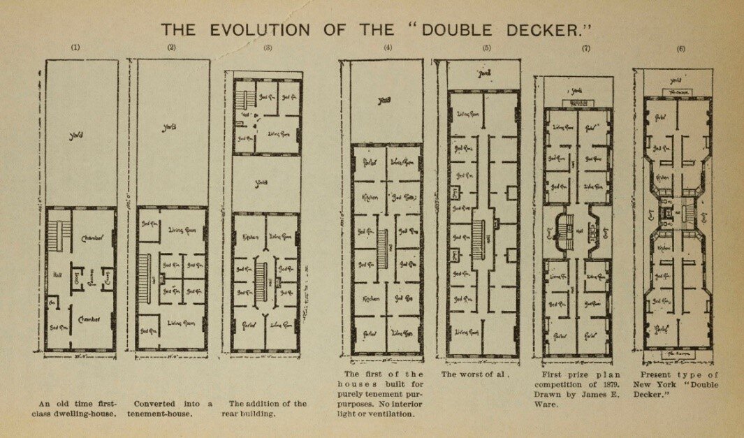
Evolution of a tenement, from single-to-multiple-family structures, an illustration from the Tenement House Commission Report of 1895. NYC Municipal Library.

Evolution of a tenement, from single-to-multiple-family structures, an illustration from the Tenement House Commission Report of 1895. NYC Municipal Library.

In addition to fire, the exponential growth of the city necessitated additional building regulations. The city’s population increased from 60,000 people in 1800, to 800,000 in 1860.  To accommodate this expansion, single-family homes were sub-divided, additional floors were added, and extensions were built into their already small yards, leaving little open space for light or ventilation. By 1865, more than 15,000 tenement-style houses had already been built.

During the 18th and 19th century the city experienced cholera, yellow fever, and typhoid epidemics. Overcrowding and close quarters with little ventilation and unsanitary conditions contributed to the spread of disease.

Caption:  The introduction of new technologies such as the elevator and steel-frame construction allowed ever-larger and taller buildings to rise in Lower Manhattan.  The collection includes an elaborate fire-escape for the building on Was…

Caption:  The introduction of new technologies such as the elevator and steel-frame construction allowed ever-larger and taller buildings to rise in Lower Manhattan.  The collection includes an elaborate fire-escape for the building on Washington Place where the Triangle Shirtwaist Factory fire occurred.  DOB Collection.  NYC Municipal Archives.

In 1860 the New York State Legislature passed “An Act to provide against unsafe buildings in the City of New York…,” calling for the appointment of a Superintendent of Buildings and a staff of inspectors. Over the next 40 years, the city and state enacted new regulations, including establishment of the Bureau of Fire Escapes and Iron Work in 1874, and the Bureaus of Plumbing, Light, and Heat in 1892.

Other laws passed in 1867 and 1879 mandated fire escapes but failed to adequately address issues of light and ventilation.  This resulted in the Tenement Act of 1901, which imposed many more regulations, such as requiring new buildings to have outward-facing windows, indoor bathrooms, proper ventilation, and increased fire safeguards.  Population growth also meant that the City’s economy grew and became more complex, creating the need for larger and more versatile spaces.

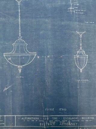
Advances in the water supply system, sanitary engineering, access to gas and electricity for illumination and cooking, and central heating systems added to the complexity of building construction and to the variety of types of plans that needed to b…

Advances in the water supply system, sanitary engineering, access to gas and electricity for illumination and cooking, and central heating systems added to the complexity of building construction and to the variety of types of plans that needed to be filed.  New lighting fixtures in the District Attorney’s office on Centre Street.  DOB Collection.  NYC Municipal Archives.

Of the thousands of plumbing drawings, one of our favorites is a very artistic sink and toilet drawing for the Manhattan House of Detention.  DOB Collection.  NYC Municipal Archives.

Of the thousands of plumbing drawings, one of our favorites is a very artistic sink and toilet drawing for the Manhattan House of Detention.  DOB Collection.  NYC Municipal Archives.

Permit and application correspondence in block and lot folders, DOB Collection.  NYC Municipal Archives.

Permit and application correspondence in block and lot folders, DOB Collection.  NYC Municipal Archives.

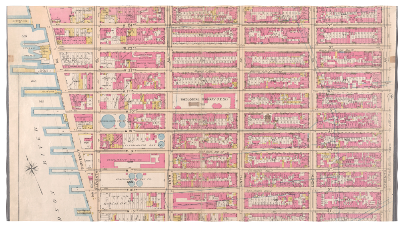
Permit applications and filed plans are arranged according to the Block and Lot number, a system that provides every city parcel of land with a unique identifying number.  Insurance atlases are a helpful tool in identifying historical block and…

Permit applications and filed plans are arranged according to the Block and Lot number, a system that provides every city parcel of land with a unique identifying number.  Insurance atlases are a helpful tool in identifying historical block and lot numbers. 1897 Bromley Atlas. New York Public Library online resource.

Increasingly, trained architects and engineers, rather than tradespeople and builders, were needed to navigate the complexities of the system and to submit plans and application forms. The DOB retained the bulk of these materials until the early 1970s when it initiated a pilot project to save space by microfilming the building plans that had accumulated over the previous century. They employed an outside vendor for the microfilming, intending to dispose of the original materials after filming. The idea of disposing of the original material raised alarms among the city’s community of historians, architects, and preservationists, including the Landmarks Preservation Commission. They monitored the quality of the microfilm and it was determined that the film did not meet accepted standards. The project was discontinued after filming the surviving plans for all buildings on the 958 blocks of Lower Manhattan below 34th Street. At that point they transferred the plans to Municipal Archives.

Roll plans from the DOB in storage. NYC Municipal Archives.

Roll plans from the DOB in storage. NYC Municipal Archives.

In 1979, an initial group of 1,000 rolls of blueprints and plans were transferred to the Municipal Archives, and more kept coming. By 1984, the archives conducted an inventory of the accumulated rolled plans and concluded that they had acquired a total of 5,738 rolls of plans. Until 2018, these plans were in storage in the same state they arrived in, occasionally being pulled by archives staff for use by researchers if they knew they existed.

In 2018, the Municipal Archives received support from the New York State Library Conservation/Preservation Discretionary Grant Program to process and re-house a subset of the Manhattan Building plans that pertained to the neighborhoods of Tribeca and Soho. This allowed staff to be hired to begin to process the plans. After the approximately 140 blocks encompassing those two neighborhoods were completed in the fall of 2019, the archivists started working on the lowest blocks in Manhattan.

Poor storage conditions and improper handling during the microfilming process resulted in damage to the plans.  DOB Collection.  NYC Municipal Archives.

Poor storage conditions and improper handling during the microfilming process resulted in damage to the plans.  DOB Collection.  NYC Municipal Archives.

Less than ideal storage conditions have led to some daunting issues in processing the collection. The microfilm vendor haphazardly and messily rewrapped the plans in acidic wrapping paper tightly tied with damaging twine and labelled the “bundle” with minimal, and often insufficient, information. 

It’s a big task for our rolled plans processing team to process and rehouse these plans to reestablish intellectual control over the material and to create more optimal retrieval and storage conditions. Here is a look at some of the tasks we perform on each roll.

Plans separated by mylar and re-rolled.  DOB Collection.  NYC Municipal Archives.

Plans separated by mylar and re-rolled.  DOB Collection.  NYC Municipal Archives.

The re-rolled plans are stored in archival containers. DOB Collection. NYC Municipal Archives. 

The re-rolled plans are stored in archival containers. DOB Collection. NYC Municipal Archives. 

First, the dusty bundles are un-rolled and the plans are identified, sorted, flattened, repaired if damaged, counted and cataloged, and carefully and neatly re-rolled onto acid-free tubes, wrapped with protective Mylar, and stored in acid-free boxes. The method for organizing the plans is according to the building’s block and lot number; all the plans for all the buildings or structures built on a particular city lot, and all the changes and alterations made to an already existing building on that lot, are stored together. When sorting the plans, we verify the block and lot information and record it in a spreadsheet, as well as addresses, quantity of plans, dates, and notes on architects, important features, and major condition concerns that are passed on to our conservation department. 

A block can contain up to 70 or 80 lots, sometimes all rolled together. Over time, when buildings are expanded or torn down, and new larger buildings are built, or buildings are combined, the lot number can change. The lot numbers written on these plans (often written very boldly in horrifying black magic marker!!!!) are essentially only accurate for the location identification as it was in the 1970s. This mean that we do not know the contents of a bundle until it is unrolled.   

When we identify the plans, we record the block and lot number from when the plan was filed as well as the current identifying information listed in the DOB BIS (Building Information System). Our concern is that researchers might request materials based on numbers from the DOB BIS, or from insurance atlases, or old block and lot maps, which may not match up with 1970s labeling. Our goal is to provide multiple entry points.  

After unrolling, plans are under boards and light weights. DOB Collection.  NYC Municipal Archives.

After unrolling, plans are under boards and light weights. DOB Collection.  NYC Municipal Archives.

The drawings span more than 100 years and many print types created by many different processes are represented in the collection. During processing they are sorted according to print type and separated by sheets of Mylar to avoid chemical migration between the different types of plans.

Plan types. Blueprint. DOB Collection. NYC Municipal Archives.

Plan types. Blueprint. DOB Collection. NYC Municipal Archives.

Plan types: Aniline print. DOB Collection. NYC Municipal Archives.

Plan types: Aniline print. DOB Collection. NYC Municipal Archives.

Plan types. Drawing on drafting linen. DOB Collection. NYC Municipal Archives. 

Plan types. Drawing on drafting linen. DOB Collection. NYC Municipal Archives. 

After processing, the containers and re-shelved. DOB Collection. NYC Municipal Archives. 

After processing, the containers and re-shelved. DOB Collection. NYC Municipal Archives. 

We have processed almost 30,000 drawings but there’s a lot more work to be done! Clearly, it is a really big, multi-year project, but it’s very worth it. Now, when we receive inquiries about plans from researchers, we can tell immediately whether we do or do not hold plans for a particular address or block and lot number, and can supply quantity and date information simply by checking the spreadsheet. Retrieval of the actual plans once they are processed takes minutes instead of hours and almost everything that has been processed is in a state that is now ready for scanning because the flattening and repair has already been performed. As of now we are scanning on demand for researchers as well as digitizing particularly interesting or beautiful plans so they can be part of our online gallery. 

It’s also worth doing the work because the collection has so much to offer that is now becoming more accessible to the public.  

Look for next week’s blog where we highlight some of the amazing plans that have been identified in the collection. 

New York Life Insurance Building, , elevation, McKim Mead & White, 1903.  Manhattan Building Plan collection. NYC Municipal Archives.

New York Life Insurance Building, , elevation, McKim Mead & White, 1903.  Manhattan Building Plan collection. NYC Municipal Archives.